Latitude: 51.8654 / 51°51'55"N
Longitude: -2.2455 / 2°14'43"W
OS Eastings: 383194
OS Northings: 218568
OS Grid: SO831185
Mapcode National: GBR 1L5.33B
Mapcode Global: VH94C.1C8S
Plus Code: 9C3VVQ83+5R
Entry Name: 6, 8 and 10, Northgate Street
Listing Date: 23 January 1952
Grade: II
Source: Historic England
Source ID: 1245712
English Heritage Legacy ID: 472365
ID on this website: 101245712
Location: Gloucester, Gloucestershire, GL1
County: Gloucestershire
District: Gloucester
Electoral Ward/Division: Westgate
Parish: Non Civil Parish
Built-Up Area: Gloucester
Traditional County: Gloucestershire
Lieutenancy Area (Ceremonial County): Gloucestershire
Church of England Parish: Hempsted with Gloucester, Saint Mary de Lode and Saint Mary de Crypt
Church of England Diocese: Gloucester
Tagged with: Building
GLOUCESTER
SO8318NW NORTHGATE STREET 844-1/8/219 (East side) 23/01/52 Nos.6, 8 AND 10
GV II
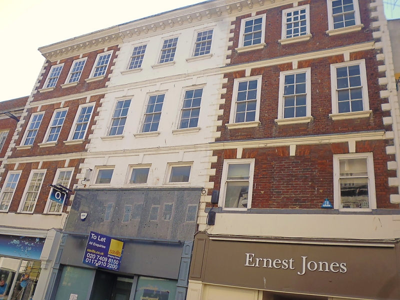
Three town houses, now a terrace of three shops and former dwellings. Early C18, C20 alterations. Red brick with stone details, the front of No.8 now painted white, slate roofs, flat to front. Double-depth block. EXTERIOR: imposing, uniform facade of four storeys, C20 shop-fronts; on the upper floors each unit of three bays is defined by chamfered stone quoins; a moulded stone string course at second and third-floor levels, and a timber crowning entablature (renewed mid C20) with a moulded modillion cornice returned onto the quoins at each end. On the first floors the central window opening of No.6 is blocked and C19 plain sashes with raised sills inserted in the openings on each side, the lower half of later plain sashes in the window openings of No.8 are concealed by a high shop fascia, in No.10 some partial sashes with glazing bars; on the second floors later sashes with thin glazing bars (2x4 panes); on the third floors the central window of No.6 has sashes with thick glazing bars (3x5 panes) and sashes with thin glazing bars on each side, in No.8 sashes with thin glazing bars (3x5 panes) and in No.10 (3x4 panes); all flush sashes in openings with rubbed, light red, flat-arched heads set with raised key stones directly below string courses and crowning entablature. INTERIOR: mostly refitted in C20; in No.8 on upper floors a C18 staircase. A five-bay four storey building with identical details, including wood modillion cornice and lead-covered flat front roof, existed at Nos 16 & 18 Westgate Street (demolished 1935). It is shown on Kip's aerial view, published in 1712, so the date of this block could be c1710.
Listing NGR: SO8319418567
External links are from the relevant listing authority and, where applicable, Wikidata. Wikidata IDs may be related buildings as well as this specific building. If you want to add or update a link, you will need to do so by editing the Wikidata entry.


Other nearby listed buildings