Latitude: 51.8672 / 51°52'1"N
Longitude: -2.2523 / 2°15'8"W
OS Eastings: 382724
OS Northings: 218765
OS Grid: SO827187
Mapcode National: GBR 1KZ.TN1
Mapcode Global: VH94B.XB5G
Plus Code: 9C3VVP8X+V3
Entry Name: Old Custom House
Listing Date: 23 January 1952
Grade: II
Source: Historic England
Source ID: 1245477
English Heritage Legacy ID: 472582
ID on this website: 101245477
Location: The Island, Gloucester, Gloucestershire, GL1
County: Gloucestershire
District: Gloucester
Electoral Ward/Division: Westgate
Parish: Non Civil Parish
Built-Up Area: Gloucester
Traditional County: Gloucestershire
Lieutenancy Area (Ceremonial County): Gloucestershire
Church of England Parish: Hempsted with Gloucester, Saint Mary de Lode and Saint Mary de Crypt
Church of England Diocese: Gloucester
Tagged with: House
GLOUCESTER
SO8218NE THE QUAY 844-1/7/369 (East side) 23/01/52 Old Custom House
GV II
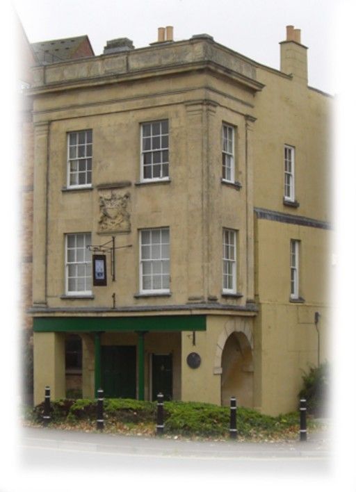
Custom House from c1700 until 1800, subsequently used for various purposes, now offices. Early C18 with a late C18 addition to the front built by agreement with the City Council in order to increase the office accommodation for the customs officers; an addition at rear originally a dwelling. Ashlar, rendered brick, slate roof. A narrow rectangular block; the upper floors of the addition to the front are supported on a colonnade facing the quay; the ground floor originally a large store room, offices on the upper floors. EXTERIOR: three storeys; on the ground floor the colonnade with two slender cast-iron columns between ashlar corner piers and at each return end an archway with impost blocks, cornice at first-floor level; the extension above the colonnade two bays in width and one-bay deep is framed by shallow, giant pilasters, slightly inset at the corners, and with moulded bases and capitals; crowning entablature with panelled parapet with moulded coping; on the front on each upper floor two sashes and on each side on the first floor a sash and and on the second floor an infilled window; all the sashes with glazing bars (3x4 panes) in similar openings with moulded sills; set centrally on the front between the first and second floors a weathered stone panel carved with the royal arms. INTERIOR: not inspected. HISTORY: in 1724 the Corporation agreed to give land, either for an extension or a new building.
Listing NGR: SO8272418764
External links are from the relevant listing authority and, where applicable, Wikidata. Wikidata IDs may be related buildings as well as this specific building. If you want to add or update a link, you will need to do so by editing the Wikidata entry.


Other nearby listed buildings