Latitude: 53.1565 / 53°9'23"N
Longitude: -1.4719 / 1°28'18"W
OS Eastings: 435412
OS Northings: 362278
OS Grid: SK354622
Mapcode National: GBR 6B5.0QL
Mapcode Global: WHDFN.CXBK
Plus Code: 9C5W5G4H+H7
Entry Name: Fallgate Mill
Listing Date: 30 August 1995
Grade: II
Source: Historic England
Source ID: 1241794
English Heritage Legacy ID: 393467
ID on this website: 101241794
Location: Fallgate, North East Derbyshire, S45
County: Derbyshire
District: North East Derbyshire
Civil Parish: Ashover
Traditional County: Derbyshire
Lieutenancy Area (Ceremonial County): Derbyshire
Church of England Parish: Ashover All Saints
Church of England Diocese: Derby
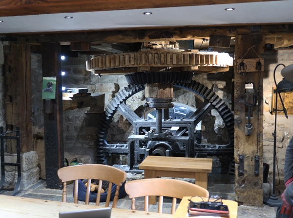
ASHOVER SK3562 HOCKLEY LANE 1264-0/12/58 (West side (off)) Fallgate Mill II Water-powered corn mill. Dated 1781, but with earlier work incorporated within the present structure. Restored 1987-8. Coursed rubble and ashlar gritstone, together with rubble carboniferous limestone, with quoins. Stone slate and pantile roof coverings, the latter with stone slated eaves. Single-storey range to the east, of brick with a stone slated roof. An irregular L-shaped grouping of buildings, the main range running east to west, with an advanced range at right angles to the main range, at the east end. The brick range is also slightly advanced. South elevation has central range of three storeys and three bays, with an off-centre doorway with massive surround and lintel, the latter inscribed 'E T S 1781'. Small single opening above doorway, and to the west a wider opening, both with plain planked doors and deep lintels. To the west, the brick outbuilding with a single central opening with planked shutter, and a small 4-pane light above. Gable to advanced range to east with a blocked ground-floor opening, a glazed first floor taking-in opening, and a small single lancet light to the gable apex. West elevation faces onto wheelpit, and is of coursed rubble. 2 rectangular openings to wall centre, one in the gable apex, the other below it, and a tall narrow opening to the south side. Set into the wheelpit a restored overshot wheel with metal sideplates and timber buckets. A metal pentrough delivers water to the wheel head. The interior and the machinery have been fully restored.
Listing NGR: SK3541262278
External links are from the relevant listing authority and, where applicable, Wikidata. Wikidata IDs may be related buildings as well as this specific building. If you want to add or update a link, you will need to do so by editing the Wikidata entry.


Other nearby listed buildings