Latitude: 52.753 / 52°45'10"N
Longitude: 0.3931 / 0°23'35"E
OS Eastings: 561604
OS Northings: 319949
OS Grid: TF616199
Mapcode National: GBR N3Q.J5J
Mapcode Global: WHJP7.02G9
Plus Code: 9F42Q93V+56
Entry Name: Bank House
Listing Date: 1 December 1951
Grade: II*
Source: Historic England
Source ID: 1220654
English Heritage Legacy ID: 384183
ID on this website: 101220654
Location: King's Lynn, King's Lynn and West Norfolk, Norfolk, PE30
County: Norfolk
District: King's Lynn and West Norfolk
Electoral Ward/Division: St Margarets with St Nicholas
Parish: Non Civil Parish
Built-Up Area: King's Lynn
Traditional County: Norfolk
Lieutenancy Area (Ceremonial County): Norfolk
Tagged with: House
KING'S LYNN
TF6119NE KING'S STAITHE SQUARE 610-1/9/112 (South side) 01/12/51 Bank House
GV II*
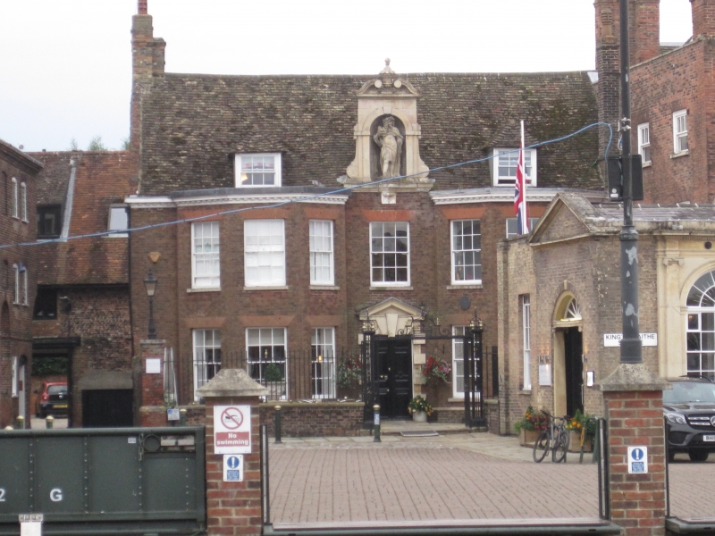
House, then hotel, now offices. Early C18. Shown on Rastrick's 1725 plan but Bell shows clear site c1680. North facade re-worked early C19 with 2 full-height canted window bays. Red brick with plain tiled roofs. North front of 2 storeys and dormer attic Central panelled door within stuccoed Gibbsian rusticated surround. One sash above with glazing bars and gauged skewback arch. Canted window bays to either side are pierced by 3 similar sashes to each floor and terminate in a timber modillion eaves cornice. Gabled roof carrying 2 hipped dormers with sashes between which is a tall stuccoed niche on scrolled consoles. Niche is framed by pilaster strips and a round arch and surmounted by a broken swan-necked pediment. In niche is a statue of Charles I, resited 1685 from former Custom House (qv) of 1630. Internal gable end stack to east and a compound stack to west gable is shared by the 3-storey wing returning north. This wing is illuminated through sashes with glazing bars and gauged skewback arches and is an early C19 front. Parapet conceals 2 hipped roofs. West elevation has large patches of English bond brickwork, is in 3 storeys and presents 4 hipped roofs to view. Windows are predominately sashes with glazing bars and exposed boxes. One stack left of centre and another immediately behind. INTERIOR. Very extensive brick cellars are barrel-vaulted. They are entered from north-east room under a heavy bressumer. This room with large but plain bridging beams. Ground floor east room with large-frame C18 panelling and a shouldered and eared picture frame in the overmantel. Reeded strips separate sashes in the window bay. Ceiling in large geometric panels. The room immediately above has similar panelling. Early C19 staircase: open string, stick balusters, ramped and wreathed handrail. Captain Samuel Gurney Cresswell, the Arctic Explorer, was born here (1827-1867). The house was built on the former site of the C16 Port Tollbooth.
Listing NGR: TF6160419948
External links are from the relevant listing authority and, where applicable, Wikidata. Wikidata IDs may be related buildings as well as this specific building. If you want to add or update a link, you will need to do so by editing the Wikidata entry.


Other nearby listed buildings