Latitude: 53.5584 / 53°33'30"N
Longitude: -2.7291 / 2°43'44"W
OS Eastings: 351800
OS Northings: 407109
OS Grid: SD518071
Mapcode National: GBR 9WC9.Y4
Mapcode Global: WH86L.1TQG
Plus Code: 9C5VH75C+99
Entry Name: Methodist Church
Listing Date: 11 August 1993
Grade: II
Source: Historic England
Source ID: 1220166
English Heritage Legacy ID: 389057
ID on this website: 101220166
Location: Roby Mill, West Lancashire, WN8
County: Lancashire
District: West Lancashire
Civil Parish: Up Holland
Traditional County: Lancashire
Lieutenancy Area (Ceremonial County): Lancashire
Church of England Parish: Up Holland St Thomas
Church of England Diocese: Liverpool
Tagged with: Protestant church building
UP HOLLAND
SD5007 ROBY MILL, Roby Mill 783-1/5/115 (East side) Methodist Church
GV II
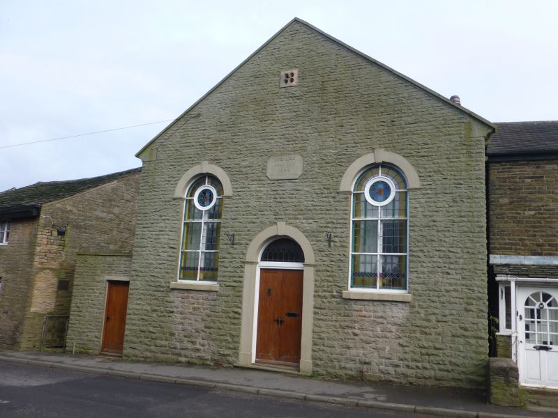
Methodist Church. Dated 1860 at 1st floor; altered. Coursed squared sandstone, slate roof. Small rectangular building at right-angles to road. Gabled 2-window facade, symmetrical; with a round-headed doorway which has a stone surround with moulded imposts and a keystone, double board doors and a fanlight with stained glass, flanked by tall round-headed windows with raised sills, stone heads like the doorway, early C20 joinery and Art Deco stained glass, a datestone above the door inscribed: JUBILEE/ METHODIST CHURCH/ 1860/ PREPARE TO MEET THY GOD O ISRAEL, and a quatrefoil in the gable. Small single-storey extension to left; C20 flat-roofed to rear, and above this 2 square windows with arched glazing (sills probably raised). Forms group with Nos 18 & 20 adjoining to the left (qv), and is included for its contribution to a good group of vernacular buildings.
Listing NGR: SD5180007109
External links are from the relevant listing authority and, where applicable, Wikidata. Wikidata IDs may be related buildings as well as this specific building. If you want to add or update a link, you will need to do so by editing the Wikidata entry.


Other nearby listed buildings