Latitude: 50.8095 / 50°48'34"N
Longitude: -2.7405 / 2°44'25"W
OS Eastings: 347923
OS Northings: 101370
OS Grid: ST479013
Mapcode National: GBR MJ.Y9J2
Mapcode Global: FRA 564Y.Q5W
Plus Code: 9C2VR755+RR
Entry Name: Devonia
Listing Date: 12 June 1953
Grade: II*
Source: Historic England
Source ID: 1220022
English Heritage Legacy ID: 393847
ID on this website: 101220022
Location: Beaminster, Dorset, DT8
County: Dorset
Civil Parish: Beaminster
Built-Up Area: Beaminster
Traditional County: Dorset
Lieutenancy Area (Ceremonial County): Dorset
Church of England Parish: Beaminster St Mary of the Annunciation
Church of England Diocese: Salisbury
Tagged with: Building
BEAMINSTER HOGSHILL STREET, ST 4701/4801 (SOUTH SIDE) 7/73 12-6-53 No 19 (Devonia) GV II*
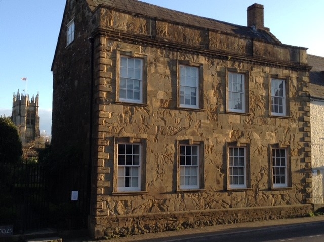
Detached Town House. Late C18. Ashlar stone front, with chamfered plinth, stone quoins, modillion cornice and parapet with own cornice. 2 storeys and attics. 4 windows, sashes with architraves, projecting keys and stone cills. Front door on south (rear) wall wood, 6 field-panles. Late C18. Rear wing has dressed stone walls to c. 9 feet. Brick walls above in Flemish bond with a brick plat band. Sash with segmental brick arch over. Thick, glazing-bars. Interior: left hand room (ground) with fielded panelling throughout, dado rail and panelling below. Moulded cornice. 6-panel doors with original brass door-furniture. Double-shutters and window seats. Doors throughout have fielded panels. Inner Hall with flagstone floor, staircase with turned balusters and panelled sides. Small cellar with brick and wooden stud partitions. Roof construction with high collars, and 2 sets of through purlins. Source: R.C.H.M. Dorset I, p 25 (28).
Listing NGR: ST4792301370
External links are from the relevant listing authority and, where applicable, Wikidata. Wikidata IDs may be related buildings as well as this specific building. If you want to add or update a link, you will need to do so by editing the Wikidata entry.


Other nearby listed buildings