Latitude: 53.3986 / 53°23'54"N
Longitude: -2.9867 / 2°59'12"W
OS Eastings: 334488
OS Northings: 389540
OS Grid: SJ344895
Mapcode National: GBR 73R.XP
Mapcode Global: WH877.3T0X
Plus Code: 9C5V92X7+C8
Entry Name: Baltic Fleet Public House
Listing Date: 14 March 1975
Grade: II
Source: Historic England
Source ID: 1218452
English Heritage Legacy ID: 359704
Also known as: Baltic Fleet
Baltic Fleet, Liverpool
ID on this website: 101218452
Location: Liverpool, Merseyside, L1
County: Liverpool
Electoral Ward/Division: Riverside
Parish: Non Civil Parish
Built-Up Area: Liverpool
Traditional County: Lancashire
Lieutenancy Area (Ceremonial County): Merseyside
Church of England Parish: St Luke in the City Team
Church of England Diocese: Liverpool
Tagged with: Pub
SJ 3489 WAPPING L1
30/1322 Baltic Fleet Public House 14.3.75. G.V. II
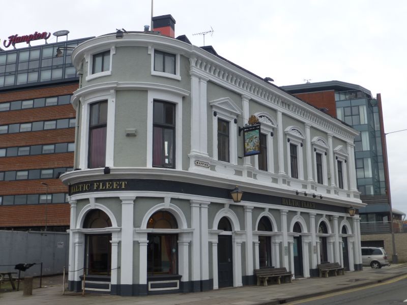
Public House. 1860. Roughcast and stone, slate roof. 2 storeys, 5 bays to Wapping, 3-bay curved corner, 4 bays to Hurst Street and 3 bays to Cornhill. Round-arched windows on ground floor divided by Tuscan pilasters; cornice; rectangular windows on 1st floor in moulded architraves with pediments (3 with carved tympana), and Tuscan pilasters between windows (paired pilasters at ends). Top cornice with brackets. Corner of 3 storeys. 1st floor has architraved windows and cornice. Architraved 2nd floor windows under cornice.
Listing NGR: SJ3448889540
External links are from the relevant listing authority and, where applicable, Wikidata. Wikidata IDs may be related buildings as well as this specific building. If you want to add or update a link, you will need to do so by editing the Wikidata entry.


Other nearby listed buildings