Latitude: 54.8986 / 54°53'55"N
Longitude: -1.3794 / 1°22'45"W
OS Eastings: 439895
OS Northings: 556167
OS Grid: NZ398561
Mapcode National: GBR VD1.TV
Mapcode Global: WHD5C.S4BG
Plus Code: 9C6WVJXC+F6
Entry Name: 17-23, Saint Bede's Terrace
Listing Date: 17 October 1994
Grade: II
Source: Historic England
Source ID: 1217868
English Heritage Legacy ID: 391580
ID on this website: 101217868
Location: Sunderland, Tyne and Wear, SR2
County: Sunderland
Electoral Ward/Division: Hendon
Parish: Non Civil Parish
Built-Up Area: Sunderland
Traditional County: Durham
Lieutenancy Area (Ceremonial County): Tyne and Wear
Church of England Parish: Hendon
Church of England Diocese: Durham
Tagged with: Building
SUNDERLAND
NZ3956SE SAINT BEDE'S TERRACE 920-1/22/205 (East side) Nos.17-23 (Consecutive)
GV II
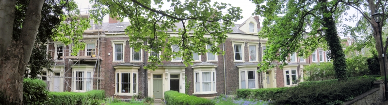
Terrace of 7 houses. c1860. English garden wall bond brick (5 and one) with painted ashlar dressings; Welsh slate roof with brick chimneys and stone gable coping. 2 storeys; most houses 3 windows. Architraves to doors of Sunderland type, some paired, panelled and folding back to form reveals to inner panelled doors and overlights; elaborate brackets to entablatures which break forward over pilasters. Ground floor canted bay windows with architraves and cornices; first floor mostly margined sashes, some renewed, in architraves with bracketed cornices. Eaves band, breaking forward over giant pilasters framing Nos 17 and 18 at left. No.23 has 6 windows, with tripartite door in third bay with tripartite window above; some renewed fixed lights with top-hung transom lights. No.21 lost door brackets. Some round-headed margined lights in gabled dormers. Transverse ridge chimneys.
Listing NGR: NZ3989556167
External links are from the relevant listing authority and, where applicable, Wikidata. Wikidata IDs may be related buildings as well as this specific building. If you want to add or update a link, you will need to do so by editing the Wikidata entry.


Other nearby listed buildings