Latitude: 51.4202 / 51°25'12"N
Longitude: -2.4302 / 2°25'48"W
OS Eastings: 370180
OS Northings: 169109
OS Grid: ST701691
Mapcode National: GBR JY.PPF3
Mapcode Global: VH88X.TKLM
Plus Code: 9C3VCHC9+3W
Entry Name: The Manor House
Listing Date: 1 February 1956
Grade: II
Source: Historic England
Source ID: 1215338
English Heritage Legacy ID: 400509
ID on this website: 101215338
Location: North Stoke, Bath and North East Somerset, Somerset, BA1
County: Bath and North East Somerset
Civil Parish: North Stoke
Traditional County: Somerset
Lieutenancy Area (Ceremonial County): Somerset
Tagged with: House Manor house
ST 76 NW NORTH STOKE
4/156 The Manor Farmhouse
1.2.56 II
G.V.
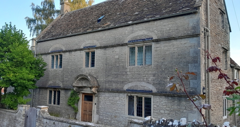
Farmhouse. Probably mid - late C17; altered and refaced c.1700. Coursed rubble with freestone dressings; Cotswold stone slate roof with coped raised verges; ashlar stacks with moulded cornice. 2 storeys, cellar to left, and attic in a central gabled dormer. 3 bays, plus one in a lower wing to the left. 3-light casement windows in ovolo moulded mullions and surrounds, under relieving arches and continuous moulded string courses over both floors. Central panelled door in bolection moulded surround and under a finely carved stone shell hood on carved consoles. Interior: large fireplace with timber lintel in room to left; stop-chamfered beams.
Listing NGR: ST7018069109
External links are from the relevant listing authority and, where applicable, Wikidata. Wikidata IDs may be related buildings as well as this specific building. If you want to add or update a link, you will need to do so by editing the Wikidata entry.


Other nearby listed buildings