Latitude: 51.4378 / 51°26'16"N
Longitude: -1.0738 / 1°4'25"W
OS Eastings: 464476
OS Northings: 171387
OS Grid: SU644713
Mapcode National: GBR B4C.Z6L
Mapcode Global: VHCZH.B4P3
Plus Code: 9C3WCWQG+4F
Entry Name: 58, 58A, and 58B, High Street
Listing Date: 14 April 1967
Last Amended: 19 June 1984
Grade: II
Source: Historic England
Source ID: 1215215
English Heritage Legacy ID: 400281
ID on this website: 101215215
Location: Theale, West Berkshire, RG7
County: West Berkshire
Civil Parish: Theale
Built-Up Area: Theale
Traditional County: Berkshire
Lieutenancy Area (Ceremonial County): Berkshire
Church of England Parish: Theale
Church of England Diocese: Oxford
Tagged with: Building
SU 6471 THEALE HIGH STREET (south side)
7/24 Nos. 58, 58A, And 58B 14.4.67 (formerly listed as No.58)
G.V. II
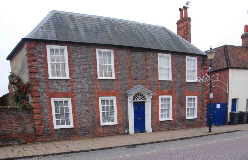
House, now flats. Early C18. Grey brick with tuck pointing and red brick dressings. Hipped slate roof. 2 storeys. Rusticated brick quoins, chaînage and gauged heads. End stack to right. 5 bays, glazing bar sashes with exposed wooden boxes, central first floor blank window. Central 6-panelled door with radial fanlight, moulded architrave and panelled pilasters supporting bracketed open triangular pediment.
Listing NGR: SU6447471386
External links are from the relevant listing authority and, where applicable, Wikidata. Wikidata IDs may be related buildings as well as this specific building. If you want to add or update a link, you will need to do so by editing the Wikidata entry.


Other nearby listed buildings