Latitude: 52.8054 / 52°48'19"N
Longitude: -2.1182 / 2°7'5"W
OS Eastings: 392130
OS Northings: 323100
OS Grid: SJ921231
Mapcode National: GBR 16X.59D
Mapcode Global: WHBDT.FRL5
Plus Code: 9C4VRV4J+5P
Entry Name: Old Sheriff's Office
Listing Date: 16 January 1951
Grade: II
Source: Historic England
Source ID: 1211232
English Heritage Legacy ID: 383945
ID on this website: 101211232
Location: Stafford, Staffordshire, ST16
County: Staffordshire
District: Stafford
Electoral Ward/Division: Forebridge
Parish: Non Civil Parish
Built-Up Area: Stafford
Traditional County: Staffordshire
Lieutenancy Area (Ceremonial County): Staffordshire
Church of England Parish: Stafford St Mary
Church of England Diocese: Lichfield
Tagged with: Architectural structure
STAFFORD
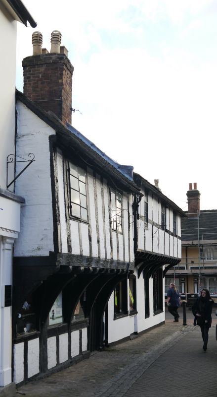
SJ9223SW CHURCH LANE 590-1/10/8 (East side) 16/01/51 No.10 Old Sheriff's Office
GV II
Includes: No.35 MILL STREET. House, now shop. C15 with late C18 addition to right and C19 additions to rear. Close-studded timber-frame with brick additions; tile roof with brick end stack. EXTERIOR: 2 storeys, 2-window range. Jettied 1st floor carried on 5 deep arch braces. Entrance to right end has wide-boarded door. 3 plate glass windows to ground floor; 2 casement windows with iron opening lights to 1st floor. INTERIOR: chamfered beams and flat joists; recorded as having some original roof structure. No.35 Mill Street is of brick; 2 storeys with jettied timber-framed 1st floor; hipped roof end Ground floor has segmental-headed entrance and 2 shop windows with cornices, all boarded at time of survey. 1st floor has 2 casement windows with 2 narrow windows to left end Right return has entrance with wedge lintel and 1st floor window with 4-pane sash. Higher 2-window range to right has cogged brick cornice and end stacks; shopfront with cornice and canopy, boarded at time of survey; 1st floor has windows with 9-pane horned sashes. Cart entry to right has remains of full cruck truss to right return wall. An interesting survival. No.35 Mill Street was listed on 17.12.71. (County Planning Department: County Sites and Monuments Record).
Listing NGR: SJ9213423101
External links are from the relevant listing authority and, where applicable, Wikidata. Wikidata IDs may be related buildings as well as this specific building. If you want to add or update a link, you will need to do so by editing the Wikidata entry.


Other nearby listed buildings