Latitude: 53.4901 / 53°29'24"N
Longitude: -2.2421 / 2°14'31"W
OS Eastings: 384034
OS Northings: 399291
OS Grid: SJ840992
Mapcode National: GBR DKC.6W
Mapcode Global: WHB9G.JJKS
Plus Code: 9C5VFQR5+25
Entry Name: Former Synagogue
Listing Date: 3 October 1974
Grade: II
Source: Historic England
Source ID: 1208420
English Heritage Legacy ID: 387986
ID on this website: 101208420
Location: Strangeways, Manchester, Greater Manchester, M4
County: Manchester
Electoral Ward/Division: Cheetham
Parish: Non Civil Parish
Built-Up Area: Manchester
Traditional County: Lancashire
Lieutenancy Area (Ceremonial County): Greater Manchester
Church of England Parish: Higher Broughton St James
Church of England Diocese: Manchester
MANCHESTER
SJ8499 CHEETHAM HILL ROAD, Cheetham 698-1/15/556 (West side) 03/10/74 No.19 (former Synagogue)
GV II
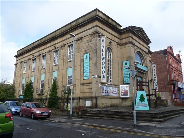
Methodist chapel, subsequently synagogue, now retail warehouse. c.1840, altered internally. Sandstone ashlar (roof concealed). Rectangular plan on corner site. Classical style. Two storeys over basement; single-storey 3-bay facade, symmetrical, the centre breaking forwards and pedimented; with plinth, pilasters, and entablature with cornice and high parapet. The projected centre has corner pilasters and a giant round-headed arch containing a square-headed doorway (approached by a broad flight of steps) with moulded architrave and cornice on consoles and flanked by narrow side-lights, and a plain semicircular window above; the outer bays have tall round-headed windows with radiating glazing bars. The 7-bay left return wall (to Park Street) has giant pilasters and 5 windows on each floor, those at ground floor altered and those at 1st floor with small-paned glazing. Interior altered.
Listing NGR: SJ8403499291
External links are from the relevant listing authority and, where applicable, Wikidata. Wikidata IDs may be related buildings as well as this specific building. If you want to add or update a link, you will need to do so by editing the Wikidata entry.


Other nearby listed buildings