Latitude: 54.9066 / 54°54'23"N
Longitude: -1.3787 / 1°22'43"W
OS Eastings: 439931
OS Northings: 557053
OS Grid: NZ399570
Mapcode National: GBR VD5.B9
Mapcode Global: WHD55.SXNX
Plus Code: 9C6WWJ4C+JG
Entry Name: Sunniside Chambers
Listing Date: 10 November 1978
Last Amended: 17 October 1994
Grade: II
Source: Historic England
Source ID: 1207148
English Heritage Legacy ID: 391645
ID on this website: 101207148
Location: Sunderland, Tyne and Wear, SR1
County: Sunderland
Electoral Ward/Division: Hendon
Parish: Non Civil Parish
Built-Up Area: Sunderland
Traditional County: Durham
Lieutenancy Area (Ceremonial County): Tyne and Wear
Church of England Parish: Hendon
Church of England Diocese: Durham
Tagged with: Building
SUNDERLAND
NZ3957SE WEST SUNNISIDE 920-1/18/236 (West side) 10/11/78 No.40 Sunniside Chambers (Formerly Listed as: WEST SUNNISIDE (West side) No.40)
GV II
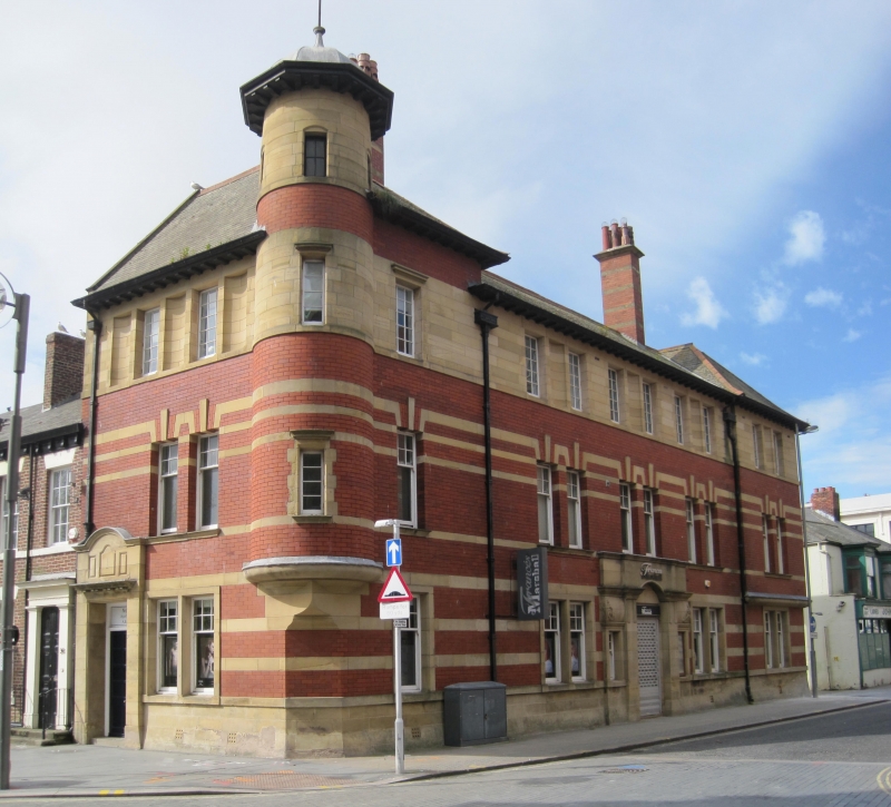
Offices. 1900-1902. By Henderson & Hall. Bright red brick with sandstone ashlar bands and dressings; roof of Lakeland slates with red ridge tiles, brick and ashlar chimneys, and lead dome. Art Nouveau style. EXTERIOR: 3 storeys, 2x8 windows and corner turret; longer front to St Thomas' Street on right return. Entrance on West Sunniside has panelled door and blocked overlight in stone surround with modillioned cornice doorhood below incised panels and segment-headed top cornice. Ashlar plinth swept to street below window at right, originally 2-light but mullion removed, on sill band which is continuous with plane of door surround; bands flush with brickwork from window surround. Paired first-floor lights above this window have upper glazing bars to sashes set well back in plain surrounds, with bands at transom, head and voussoir levels and alternate ashlar and brick voussoirs and high keystone. Top floor ashlar above sill band of 2 lights in plain surround alternating with 3 recessed panels. Corner turret at right projects from first-floor level on corbelled wide ashlar bracket; single narrow lights on 3 floors, third floor tapered and the whole perhaps showing entasis; bands continue from front and around bracket to return. Steeply-pitched hipped roof, interrupted by turret, has wide modillioned eaves projecting to plane of turret; turret has ogee octagonal roof with wide modillioned eaves and top disc-and-spike finial. Tall chimneys on ridge of right return. Front to St Thomas' Street has higher eaves in first bay adjacent to turret, projecting right end bay, central wide entrance with altered fascia flanked by mullioned lights. (Corfe T: The Buildings of Sunderland 1814-1914.: Newcastle upon Tyne: 1983-: 15).
Listing NGR: NZ3993157053
External links are from the relevant listing authority and, where applicable, Wikidata. Wikidata IDs may be related buildings as well as this specific building. If you want to add or update a link, you will need to do so by editing the Wikidata entry.


Other nearby listed buildings