Latitude: 52.0021 / 52°0'7"N
Longitude: -2.1627 / 2°9'45"W
OS Eastings: 388925
OS Northings: 233750
OS Grid: SO889337
Mapcode National: GBR 1JK.D1F
Mapcode Global: VH93M.GYJ2
Plus Code: 9C4V2R2P+RW
Entry Name: Toll House at East End of Mythe Bridge
Listing Date: 27 July 1973
Last Amended: 25 April 1994
Grade: II
Source: Historic England
Source ID: 1204474
English Heritage Legacy ID: 376565
ID on this website: 101204474
Location: The Mythe, Tewkesbury, Gloucestershire, GL20
County: Gloucestershire
District: Tewkesbury
Civil Parish: Tewkesbury
Traditional County: Gloucestershire
Lieutenancy Area (Ceremonial County): Gloucestershire
Church of England Parish: Tewkesbury St Mary the Virgin (Tewkesbury Abbey)
Church of England Diocese: Gloucester
Tagged with: Tollhouse
TEWKESBURY
SO83SE A438, The Mythe 859-1/2/389 (North side) 27/07/73 Toll House at east end of Mythe Bridge (Formerly Listed as: THE MYTHE The Tollhouse Mythe Bridge)
GV II
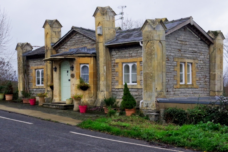
Toll house. 1826-30. Probably from Telford's office. Coursed lias with limestone dressings, slate roof. A long, cross-gabled plan, with the entrance at the upper, street level; a C20 two-storey wing has been added at the river end, and a flat-roofed single-storey extension across the back at the lower level. To the road the central flat octagonal bay is flanked by 2-light mullioned casements with 4-centred heads in dressed stone set flush, with alternating quoins. A 6-panel door in 4-centred head has small square lights on the splayed returns. At each side of the bay, and at gable ends are square limestone buttresses with narrow panels to pointed heads, carried up as pinnacles to a cross-gabled top. There is a glacis-like weathered plinth, and the eaves has a continuous course of crocket-like stone brackets, carried also into the shallow central gable. The left return has a 2-light casement at each level, and the right return a 2-light above a flat-roofed extension. The back is detailed as for the front, but with 2-light casement at first floor in the slightly projecting gable. A flat-roofed extension is carried across the ground floor, and connects with the new 2-storey wing. Although considerably extended, the toll house is not altered on its street front. It faces the turnpike shelter (qv) on the opposite side of the road.
Listing NGR: SO8892533750
External links are from the relevant listing authority and, where applicable, Wikidata. Wikidata IDs may be related buildings as well as this specific building. If you want to add or update a link, you will need to do so by editing the Wikidata entry.


Other nearby listed buildings