Latitude: 51.4475 / 51°26'50"N
Longitude: -2.5951 / 2°35'42"W
OS Eastings: 358738
OS Northings: 172220
OS Grid: ST587722
Mapcode National: GBR C8M.1Z
Mapcode Global: VH88M.YWX8
Plus Code: 9C3VCCW3+XX
Entry Name: Robinson's Warehouse
Listing Date: 2 April 1973
Last Amended: 30 December 1994
Grade: II
Source: Historic England
Source ID: 1204025
English Heritage Legacy ID: 378928
ID on this website: 101204025
Location: Canon's Marsh, Bristol, BS1
County: City of Bristol
Electoral Ward/Division: Central
Parish: Non Civil Parish
Built-Up Area: Bristol
Traditional County: Somerset
Lieutenancy Area (Ceremonial County): Bristol
Church of England Parish: St Mary Redcliffe with Temple, Bristol and St John the Baptist, Bedminster
Church of England Diocese: Bristol
Tagged with: Architectural structure Byzantine Revival architecture
BRISTOL
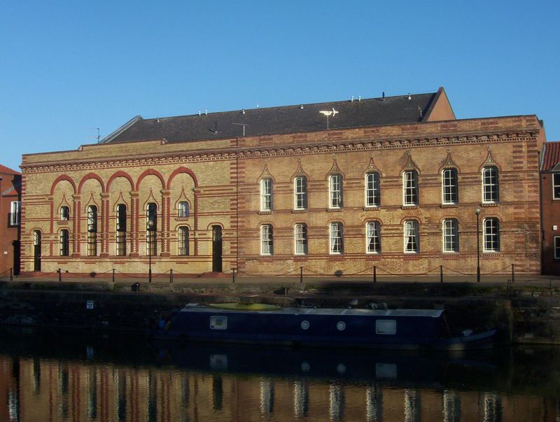
ST5872 BATHURST PARADE 901-1/42/5 (North West side) 02/04/73 Robinson's Warehouse (Formerly Listed as: BATHURST PARADE Warriner's Warehouse (left-hand)) (Formerly Listed as: BATHURST PARADE Warriner's Warehouse (right-hand))
GV II
Warehouse and office, now offices. 1875, reconstructed 1981 behind the facades. By WB Gingell. Yellow brick with red brick and moulded brick dressings. Polychromatic Venetian Gothic style. Each of 2 storeys; 7-window range. Though not bonded, the cornice and parapet of the 2 facades are continuous, and they have a common decoration: red and yellow brick quoins, sill bands, impost bands with angled brick panels, and diagonally-set bricks below a bracketed cornice. The left-hand block has outer doorways, formerly windows, with curved corners to the heads; the 3 middle windows are full height, all 5 have red ogee hoods on the first floor, and are set within semicircular-arched recesses with parabolic-arched extrados; ramped centre to the parapet. Similar right-hand block has no arched recesses or full-height windows. Sash windows with margin bars. INTERIOR: converted to squash courts and offices. HISTORICAL NOTE: originally part of John Robinson's Oil Seed Mill, the mill was demolished in 1981 and the facades retained. (Gomme A, Jenner M and Little B: Bristol, an Architectural History: Bristol: 1979-: 370; Lord J and Southam J: The Floating Harbour: Bristol: 1983-: 94).
Listing NGR: ST5873872220
External links are from the relevant listing authority and, where applicable, Wikidata. Wikidata IDs may be related buildings as well as this specific building. If you want to add or update a link, you will need to do so by editing the Wikidata entry.


Other nearby listed buildings