Latitude: 54.0441 / 54°2'38"N
Longitude: -2.7995 / 2°47'58"W
OS Eastings: 347747
OS Northings: 461198
OS Grid: SD477611
Mapcode National: GBR 8PWP.Q1
Mapcode Global: WH846.ZM22
Plus Code: 9C6V26V2+J6
Entry Name: Royal Lancaster Infirmary (Original Building)
Listing Date: 13 March 1995
Grade: II
Source: Historic England
Source ID: 1194932
English Heritage Legacy ID: 383048
ID on this website: 101194932
Location: Primrose, Lancaster, Lancashire, LA1
County: Lancashire
District: Lancaster
Electoral Ward/Division: Scotforth West
Parish: Non Civil Parish
Built-Up Area: Lancaster
Traditional County: Lancashire
Lieutenancy Area (Ceremonial County): Lancashire
Church of England Parish: Lancaster St Mary with St John and St Anne
Church of England Diocese: Blackburn
Tagged with: Hospital building
LANCASTER
SD4761SE ASHTON ROAD 1685-1/8/12 (West side) Royal Lancaster Infirmary (original building)
GV II
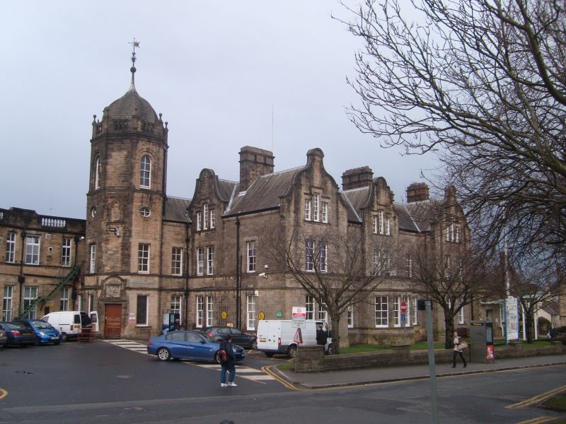
Hospital. 1896, altered and extended 1929. Designed by Paley and Austin. Sandstone ashlar with slate roofs. Free Renaissance style. Originally a reversed L-shaped plan arranged symmetrically around an octagonal 4-stage entrance tower, and altered by the construction of a long extension on the left. Above the entrance doorway is a square niche framed with strapwork and filled with a Coade stone plaque, representing the Good Samaritan. This was previously placed above the entrance of the dispensaries at No.19 Castle Hill (qv) and No.6 Thurnham Street (qv). The upper faces of the tower above the doorway are blind, but on the third floor an aedicule contains the royal coat of arms. On either side of the entrance the faces of the tower are canted backwards and have a rectangular window on the ground and first floors. All the windows have quadrant-moulded architraves and a keystone and are sashed with glazing bars. On the second floor is a bull's eye window, and on the third a round-headed window; above is a balustrade which hides the base of an ogee-shaped dome. To the right of the tower is the 2-bay return wall of the right-hand original block, which has 2 storeys, plus gabled attics, and 5 wide bays arranged as a recessed centre and 2 cross-wings. These have paired windows on the ground and first floors and a stepped 3-light window under a Flemish gable. The central bay has a similar gable and paired windows on the first floor, but the ground floor has a canted bay window. To the far right is a single-storey wing containing an entrance with a battlemented lintel and a datestone, all set under a Flemish gable, which has a bull's eye window.
Listing NGR: SD4774761198
External links are from the relevant listing authority and, where applicable, Wikidata. Wikidata IDs may be related buildings as well as this specific building. If you want to add or update a link, you will need to do so by editing the Wikidata entry.


Other nearby listed buildings