Latitude: 52.2151 / 52°12'54"N
Longitude: -2.1434 / 2°8'36"W
OS Eastings: 390300
OS Northings: 257440
OS Grid: SO903574
Mapcode National: GBR 1G1.4WZ
Mapcode Global: VH92N.SLR8
Plus Code: 9C4V6V84+2J
Entry Name: The Forge
Listing Date: 13 July 1979
Grade: II
Source: Historic England
Source ID: 1180010
English Heritage Legacy ID: 147889
ID on this website: 101180010
Location: Tibberton, Wychavon, Worcestershire, WR9
County: Worcestershire
District: Wychavon
Civil Parish: Tibberton
Built-Up Area: Tibberton
Traditional County: Worcestershire
Lieutenancy Area (Ceremonial County): Worcestershire
Church of England Parish: Hadzor with Oddingley and Tibberton
Church of England Diocese: Worcester
Tagged with: Smithy
TIBBERTON CP PLOUGH ROAD (west side) SO 95 NW 6/213 (18/95) The Forge 13.7.79 - II
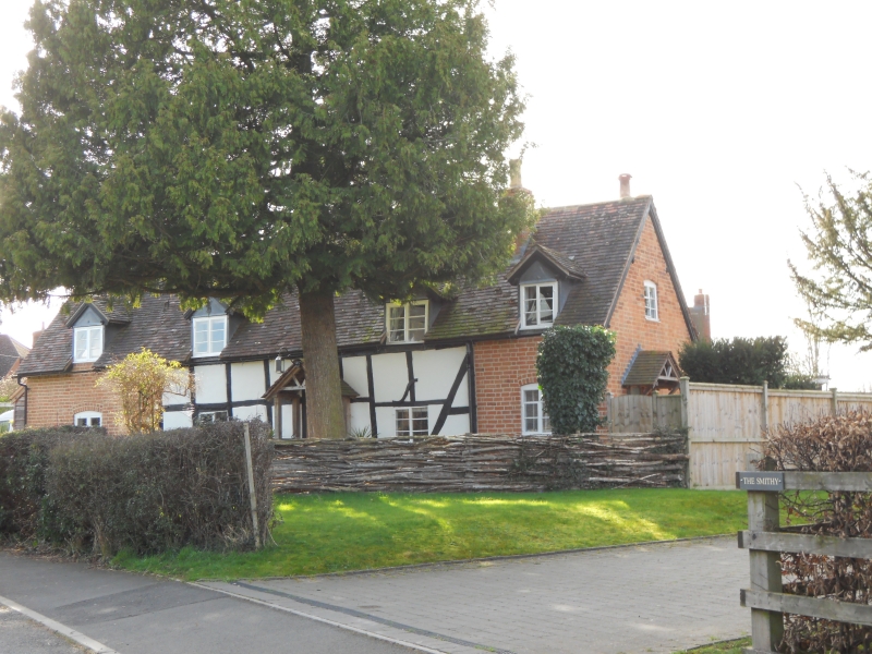
House. C17 with early C20 alterations and additions. Timber-framed with painted brick and rendered infill, brick additions partly painted to resemble framing and plain tiled roof. Two framed bays aligned north-west/south-east; external chimney at north-west gable end enclosed within single-bay addition; also single-bay addition at south-east gable end with large stack to rear roof pitch. Single storey and attic. Framing: three panels from sill to wall-plate; long straight braces in lower corners; no trusses visible. North-east front elevation: ground floor has four 2-light casements, the two in the brick additions have cambered heads; four gabled dormers with 2-light casements; two gabled timber porches with lattice side infill and ledged and battened doors; the left door has a cambered head. Attic lights in gable ends. Interior not inspected but said to retain its framing. Outshut at rear.
Listing NGR: SO9030057440
External links are from the relevant listing authority and, where applicable, Wikidata. Wikidata IDs may be related buildings as well as this specific building. If you want to add or update a link, you will need to do so by editing the Wikidata entry.


Other nearby listed buildings