Latitude: 50.5813 / 50°34'52"N
Longitude: -3.4672 / 3°28'2"W
OS Eastings: 296216
OS Northings: 76757
OS Grid: SX962767
Mapcode National: GBR P2.RC58
Mapcode Global: FRA 37MJ.H22
Plus Code: 9C2RHGJM+G4
Entry Name: Lloyds Bank
Listing Date: 21 March 1985
Grade: II
Source: Historic England
Source ID: 1164411
English Heritage Legacy ID: 84418
ID on this website: 101164411
Location: Dawlish, Teignbridge, Devon, EX7
County: Devon
District: Teignbridge
Civil Parish: Dawlish
Built-Up Area: Dawlish
Traditional County: Devon
Lieutenancy Area (Ceremonial County): Devon
Church of England Parish: Dawlish St Gregory
Church of England Diocese: Exeter
Tagged with: Bank building
SX 9676 DAWLISH THE STRAND
8/97 Lloyds Bank _ _ II
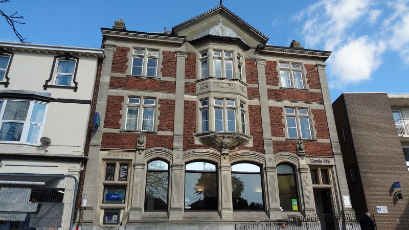
C1890. 3 storeys sandstone with stone dressings. Central gable with carved stone devil. 3 windows separated by pilasters. The central window is a 2 storey oriel with cherub, swag and cornucopia moulding between floors and carved eagle supporting oriel. Ground floor has segmental arched windows with pilasters, 2 of them supporting dragon and griffin with shields.
Listing NGR: SX9621676757
External links are from the relevant listing authority and, where applicable, Wikidata. Wikidata IDs may be related buildings as well as this specific building. If you want to add or update a link, you will need to do so by editing the Wikidata entry.


Other nearby listed buildings