The listing was removed on 1 October 2015.
This building has been assessed for de-listing under the Planning (Listed Buildings and Conservation Areas) Act 1990 as amended. The building has been removed from The National Heritage List for England as it no longer meets the criteria for listing.
The information below has been retained for archive purposes. It does not necessarily reflect the current state of the building.
Latitude: 53.1132 / 53°6'47"N
Longitude: -2.2144 / 2°12'51"W
OS Eastings: 385748
OS Northings: 357352
OS Grid: SJ857573
Mapcode National: GBR 12X.YST
Mapcode Global: WHBCD.Y0QQ
Plus Code: 9C5V4Q7P+77
Entry Name: Mow Cop Castle
Listing Date: 6 June 1952
Last Amended: 26 March 1987
Delisted Date: 1 October 2015
Grade: II
Source: Historic England
Source ID: 1162028
English Heritage Legacy ID: 56556
ID on this website: 101162028
Location: Mow Cop, Newcastle-under-Lyme, Staffordshire, ST7
County: Cheshire East
District: Newcastle-under-Lyme
Civil Parish: Kidsgrove
Built-Up Area: Kidsgrove
Traditional County: Staffordshire
Lieutenancy Area (Ceremonial County): Cheshire
Church of England Parish: Odd Rode All Saints
Church of England Diocese: Chester
SJ 85 NE
8/83
6.6.52
ODD RODE C.P.
(Off) HIGH STREET
(MOW COP)
Mow Cop Castle
(formerly listed as Summer House on Mow Cop)
II
GV
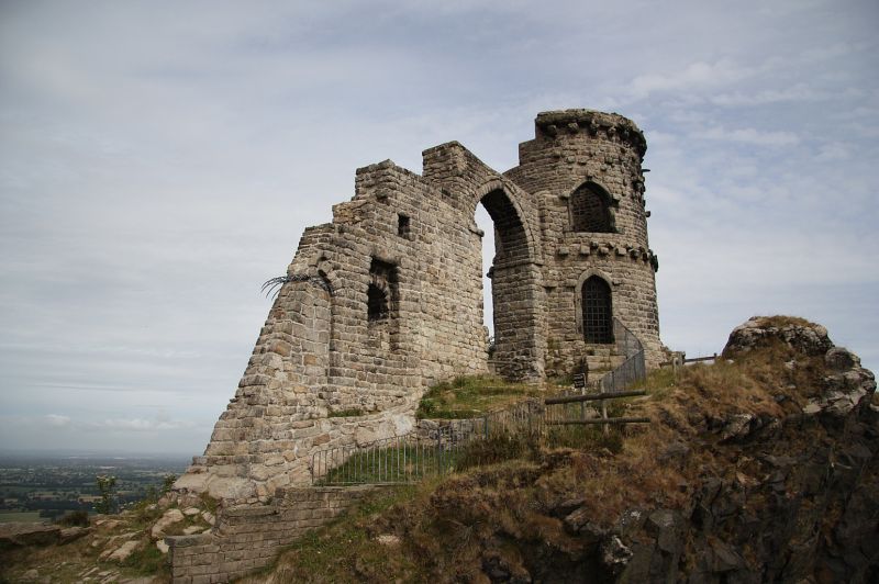
Ruinous folly built as a summer house. 1754. By Randle Wilbraham.
Coursed sandstone rubble. Round tower to north with ground floor and
ruinous upper floor and arch and broken walling to south. Cheshire
front: round tower at left with two porthole windows to the ground
floor. Row of corbels above this and one pointed arch at left. To
right of the tower is a pointed arch and at right again a further
piece of ruinous walling with a low porthole window and half of a
blocked pointed arch. The Staffordshire side has a porthole window at
right of the round tower and a pointed arched doorway at left, a row
of corbels dividing the floors and two pointed arches to the first
floor with a corbel table below the parapet. Pointed arch to left of
this and rectangular surround to the sunken porthole window in the
walling at left. The round tower was originally less ruinous and had
Y-tracery to the pointed windows and a conical roof, and served as a
summer-house for the Wilbrahams and a neighbouring family of
Staffordshire landowners. In the late C18 the first meetings of the
Primitive Methodists were held below the castle. The castle was built
on the county boundary.
Listing NGR: SJ 85748 57352
External links are from the relevant listing authority and, where applicable, Wikidata. Wikidata IDs may be related buildings as well as this specific building. If you want to add or update a link, you will need to do so by editing the Wikidata entry.


Other nearby listed buildings