Latitude: 51.8661 / 51°51'58"N
Longitude: -0.8304 / 0°49'49"W
OS Eastings: 480628
OS Northings: 219262
OS Grid: SP806192
Mapcode National: GBR D24.T11
Mapcode Global: VHDTY.KCB8
Plus Code: 9C3XV589+CR
Entry Name: The Maltings
Listing Date: 29 January 1985
Grade: II
Source: Historic England
Source ID: 1158209
English Heritage Legacy ID: 42166
ID on this website: 101158209
Location: Hardwick, Buckinghamshire, HP22
County: Buckinghamshire
Civil Parish: Hardwick
Traditional County: Buckinghamshire
Lieutenancy Area (Ceremonial County): Buckinghamshire
Church of England Parish: Hardwick
Church of England Diocese: Oxford
Tagged with: Architectural structure
SP 81 NW HARDWICK LOWER ROAD
6/17 The Maltings
-
- II
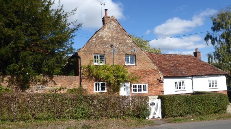
House. Early C18, altered and extended. Pale red and vitreous header brick with pale red brick window surrounds, moulded plinth and moulded wooden eaves cornice. Tiled roof, central brick chimney. L-plan, the rear wing a C18-C19 addition. 2 storeys and attic, 2 bays and lobby entry. Ground floor has 2 cross casements to each bay, all with high transoms and irregular barred wooden and leaded lights. First floor has similar windows, one 3-light to each bay, and 2-light over central door. Flush-panelled door, top-lit, in wooden architrave surround with pulvinated frieze and moulded cornice. Sun fire insurance plaque above. Paired leaded casement to attic in left gable. Leaded casements in rear wing. Interior shows some timber framing in rear wall, stop- chamfered spine beam in right room, C18 doors and dados, and late C18 corner cupboard with shaped shelves in left room.
Listing NGR: SP8062819262
External links are from the relevant listing authority and, where applicable, Wikidata. Wikidata IDs may be related buildings as well as this specific building. If you want to add or update a link, you will need to do so by editing the Wikidata entry.


Other nearby listed buildings