Latitude: 51.4568 / 51°27'24"N
Longitude: -0.9683 / 0°58'5"W
OS Eastings: 471776
OS Northings: 173600
OS Grid: SU717736
Mapcode National: GBR QMF.L6
Mapcode Global: VHDWT.5NF1
Plus Code: 9C3XF24J+PM
Entry Name: Wall and gate piers of the Church of St Laurence’s graveyard
Listing Date: 19 March 1975
Last Amended: 9 July 2024
Grade: II
Source: Historic England
Source ID: 1155686
English Heritage Legacy ID: 38930
ID on this website: 101155686
Location: Reading, Berkshire, RG1
County: Reading
Electoral Ward/Division: Abbey
Parish: Non Civil Parish
Built-Up Area: Reading
Traditional County: Berkshire
Lieutenancy Area (Ceremonial County): Berkshire
Church of England Parish: Reading St Mary the Virgin
Church of England Diocese: Oxford
Tagged with: Wall
Churchyard wall and gate originally built in the C16, significantly rebuilt in 1791 with later repairs to sections.
Churchyard wall and gate, built in the C16, largely rebuilt in 1791 with repairs of the C19 and C20. The wall was restored in around 2015.
MATERIALS: red brick with Taynton Stone, Hornton Stone, flint, and wrought iron elements. The gate piers are of red brick with ashlar limestone ornament.
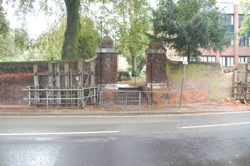
DESCRIPTION: the wall encloses the Church of St Laurence’s graveyard on its east, south, and south-east sides, beginning at the church to the south-west and culminating at Minerva House to the north-east. The south section of the churchyard wall is of two halves; the lower half contains large sections of Taynton and Hornton Stone combined with smaller knapped flints, while the upper half is red brick laid in English bond and topped with rounded brick coping. The south-east section of the wall is entirely red brick, laid inconsistently in Flemish Bond. The east section is also red brick; however, the lower half looks to be older and is laid in English Cross bond. Towards the northern side of the eastern wall section is an opening into the graveyard, flanked on either side by large brick gate piers with limestone plinths, block capping and topped with ball finials. Part of the stone capping is engraved ‘REBUILT AD 1791’. Over the entrance is a wrought iron overthrow with lamp.
Modest rural settlements likely existed in the area of Reading as far back as the first century. By the time of the Norman Conquest of 1066, Reading had become a town of notable size. After Reading Abbey was founded in 1121, the town grew substantially, spurred by cloth production, the establishment of the new Market Place, and what would today be known as London Street, an extension to the High Street that facilitated trade to and from London. By 1525, the town’s thriving cloth industry led Reading to become the largest town in Berkshire. In 1542, Henry VIII’s royal charter made Reading a borough. Following significant upheaval during the Civil War, the town flourished during C18 and C19. Several developments during the late C18 and C19 spurred further growth and prosperity, including the arrival of the Great Western Railway, improvements to the navigability of the River Kennet, and the growth of the local brewing industry.
The Church of St Laurence has its origins in the Norman period, though much of it is of C12 construction. The wall which surrounds its churchyard was likely built in the mid-C16 under the patronage of Mary I. It was almost entirely rebuilt in 1791, with the retention of the earlier, flint and limestone lower section of the southward-facing, western section. Sections were rebuilt or repaired in the C19 and C20. Major repair works were carried out on the severely deteriorated wall in around 2015.
External links are from the relevant listing authority and, where applicable, Wikidata. Wikidata IDs may be related buildings as well as this specific building. If you want to add or update a link, you will need to do so by editing the Wikidata entry.


Other nearby listed buildings