Latitude: 54.2026 / 54°12'9"N
Longitude: -1.0838 / 1°5'1"W
OS Eastings: 459861
OS Northings: 478930
OS Grid: SE598789
Mapcode National: GBR NMWV.47
Mapcode Global: WHF9Y.BM4K
Plus Code: 9C6W6W38+3F
Entry Name: Bridge from Abbey Precinct Across Road to Ampleforth Bank
Listing Date: 9 September 1985
Grade: II
Source: Historic England
Source ID: 1149605
English Heritage Legacy ID: 329563
ID on this website: 101149605
Location: North Yorkshire, YO62
County: North Yorkshire
District: Ryedale
Civil Parish: Ampleforth
Traditional County: Yorkshire
Lieutenancy Area (Ceremonial County): North Yorkshire
Church of England Parish: Ampleforth St Hilda
Church of England Diocese: York
Tagged with: Bridge
AMPLEFORTH AMPLEFORTH ABBEY SE 57 NE
5/4 Bridge from Abbey Precinct across road to
9.9.85 Ampleforth Bank
The description shall be amended to read:
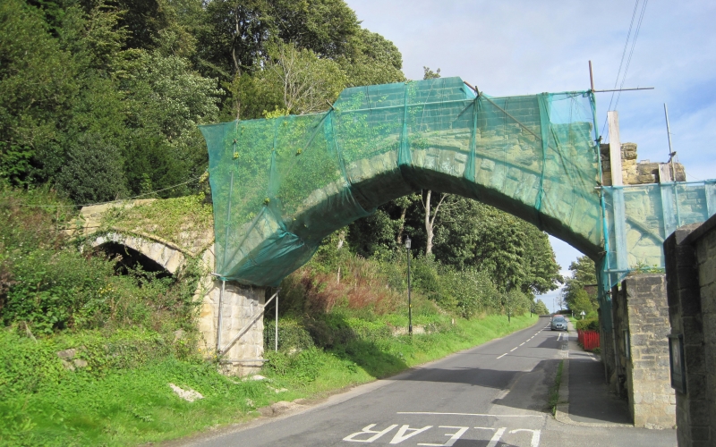
Footbridge. c1854, restored c1930. Rusticated limestone ashlar. Single span across road with second arch built into the slope of the bank, a further third arch formerly led down into the Abbey precinct, but this has been demolished. Stepped parapet, rebuilt at top c1930. The bridge post-dates a Royal Proclamation issued 15th June 1854 forbidding the wearing of Catholic vestments and ornaments in public, for the bridge was designed to link the abbey with the cemetery on Ampleforth Bank.
------------------------------------
AMPLEFORTH AMPLEFORTH ABBEY SE 57 NE
5/4 Bridge from abbey precinct across road to 9.9.85 Ampleforth Bank
GV II
Bridge. Probably early C19 in origin with later rebuilding. Rusticated limestone ashlar. Single span across road with a second arch built into the slope of the bank. Stepped parapet, rebuilt at top. In origin the bridge may pre-date the 1829 Catholic Emancipation Act, its purpose being to shield the monks from sight as they crossed the road.
Listing NGR: SE5986178930
External links are from the relevant listing authority and, where applicable, Wikidata. Wikidata IDs may be related buildings as well as this specific building. If you want to add or update a link, you will need to do so by editing the Wikidata entry.


Other nearby listed buildings