Latitude: 54.4737 / 54°28'25"N
Longitude: -2.1935 / 2°11'36"W
OS Eastings: 387558
OS Northings: 508725
OS Grid: NY875087
Mapcode National: GBR FJ3Q.X2
Mapcode Global: WHB4N.8TQ7
Plus Code: 9C6VFRF4+FJ
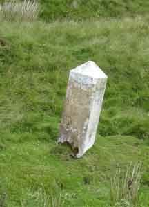
Entry Name: Boundary Stone on North Side of Road to North West of Gate House
Listing Date: 21 June 1984
Grade: II
Source: Historic England
Source ID: 1144885
English Heritage Legacy ID: 73344
ID on this website: 101144885
Location: Westmorland and Furness, Cumbria, CA17
County: Westmorland and Furness
District: Eden
Civil Parish: Stainmore
Traditional County: Westmorland
Lieutenancy Area (Ceremonial County): North Yorkshire
Church of England Parish: Brough St Michael
Church of England Diocese: Carlisle
Tagged with: Boundary marker
NY 875 087 KABER NY 80 NE Boundary stone on north side of road to north- 13/59 west of Gate House
II
Boundary stone; C19. Single stone c3 ft high with angled sides and segmental top. Inscribed in sans serif lettering: TOWNSHIP OF SOUTH STAINMORE on north face, TOWNSHIP OF KABER on south.
Listing NGR: NY8755808725
External links are from the relevant listing authority and, where applicable, Wikidata. Wikidata IDs may be related buildings as well as this specific building. If you want to add or update a link, you will need to do so by editing the Wikidata entry.


Other nearby listed buildings