Latitude: 54.7996 / 54°47'58"N
Longitude: -2.7333 / 2°43'59"W
OS Eastings: 352956
OS Northings: 545210
OS Grid: NY529452
Mapcode National: GBR 9DCY.18
Mapcode Global: WH80K.ZMLG
Plus Code: 9C6VQ7X8+RM
Entry Name: Bascodyke
Listing Date: 3 August 1984
Grade: II
Source: Historic England
Source ID: 1144843
English Heritage Legacy ID: 73445
ID on this website: 101144843
Location: Ruckcroft, Westmorland and Furness, Cumbria, CA4
County: Westmorland and Furness
District: Eden
Civil Parish: Ainstable
Traditional County: Cumberland
Lieutenancy Area (Ceremonial County): Cumbria
Church of England Parish: Ainstable St Michael
Church of England Diocese: Carlisle
Tagged with: Building
NY 52950 45200 AINSTABLE NY 54 NW
3/18 Bascodyke
II
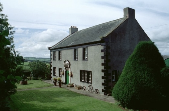
Farmhouse. Probably late C17, with alterations dated 1747 and initials I.(&)R.S. on rear lintel, but originally the Hodgson family home. Rendered walls with raised painted quoins and plain painted stone cornice; graduated slate roof with coped gables and kneelers, rendered chimney stacks. 2 storeys, 4 bays. Plank door with glazed segmental fanlight has pilastered surround with triglyph entablature and dentilled segmental pediment. 3-light mullioned window to right has moulded surround and glazing bar casements. Other windows are sashes with glazing bars and casements with glazing bars, all with moulded stone surrounds. Interior has oak beams in principal rooms and carved oak doors. See, Transactions Cumberland & Westmorland Antiquarian Archaeological Society, xxv, p.244-267. Name derives from the nearby dyke constructed as protection against border raiders.
Listing NGR: NY5295645210
External links are from the relevant listing authority and, where applicable, Wikidata. Wikidata IDs may be related buildings as well as this specific building. If you want to add or update a link, you will need to do so by editing the Wikidata entry.


Other nearby listed buildings