Latitude: 52.9522 / 52°57'7"N
Longitude: -1.4448 / 1°26'41"W
OS Eastings: 437400
OS Northings: 339568
OS Grid: SK374395
Mapcode National: GBR PS3.C2
Mapcode Global: WHDGT.S263
Plus Code: 9C4WXH24+V3
Entry Name: Methodist Chapel
Listing Date: 6 November 1986
Grade: II
Source: Historic England
Source ID: 1141229
English Heritage Legacy ID: 352209
ID on this website: 101141229
Location: Breadsall, Erewash, Derbyshire, DE21
County: Derbyshire
District: Erewash
Civil Parish: Breadsall
Built-Up Area: Breadsall
Traditional County: Derbyshire
Lieutenancy Area (Ceremonial County): Derbyshire
Church of England Parish: Breadsall All Saints
Church of England Diocese: Derby
Tagged with: Chapel
PARISH OF BREADSALL BROOKSIDE ROAD SK 33 NE 4/3 (South Side) Methodist Chapel II
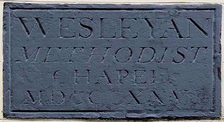
Chapel. Dated 1826. Rendered brick with Welsh slate roof. North elevation of two bays. Central early C20 porch with flat roof and panelled double doors. Flanked on each side by semi-circular headed windows with early C20 glazing bars and 'Art Nouveau' coloured glass. Plain stringcourse above, at the base of the stepped and ramped parapet with gabled top. Above the stringcourse is a date plaque inscribed 'Wesleyan Methodist Chapel MDCCCXXVI'. The south elevation has two windows similar to those on the north elevation. Plain interior with C20 fittings.
Listing NGR: SK3740039568
External links are from the relevant listing authority and, where applicable, Wikidata. Wikidata IDs may be related buildings as well as this specific building. If you want to add or update a link, you will need to do so by editing the Wikidata entry.


Other nearby listed buildings