Latitude: 51.4507 / 51°27'2"N
Longitude: -0.967 / 0°58'1"W
OS Eastings: 471878
OS Northings: 172923
OS Grid: SU718729
Mapcode National: GBR QMH.WD
Mapcode Global: VHDWT.6S4Q
Plus Code: 9C3XF22M+76
Entry Name: Sargents Embrook
Listing Date: 19 March 1975
Grade: II
Source: Historic England
Source ID: 1113521
English Heritage Legacy ID: 39040
ID on this website: 101113521
Location: Reading, Berkshire, RG1
County: Reading
Electoral Ward/Division: Katesgrove
Parish: Non Civil Parish
Built-Up Area: Reading
Traditional County: Berkshire
Lieutenancy Area (Ceremonial County): Berkshire
Church of England Parish: Reading St Giles
Church of England Diocese: Oxford
Tagged with: Building
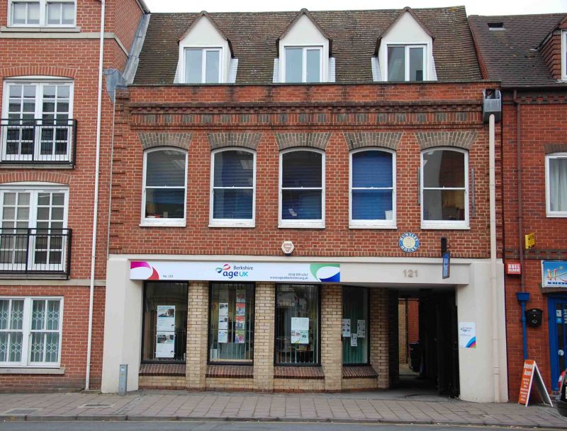
LONDON STREET 1. 5128 (East Side) Nos 119 and 121 (Sargents Embrook) SU 7172 NE 4/190 19.3.75. II 2. Early-mid C18 altered. 2 storeys and attic, early subsidence has caused considerable distortion to front (now consolidated). Red brick with silver grey arches to 1st floor windows. Silver grey brick frieze and cornice with red squares in frieze. Rusticated painted brick quoins. Plain parapet. Old tile roof. 3 gabled dormers. 5 segmental headed windows on 1st floor (no glazing bars). Plain early C19 shop front with Doric pilasters and cornice (again no glazing bars). Originally the Huntley and Palmer shop. Interior: biscuit oven/fireplace retained (but now boxed in). 1st floor north-east roof has arch headed corner cupboard with raised and fielded panels. Throughpassage to south with traces of timbering.
Listing NGR: SU7187872923
External links are from the relevant listing authority and, where applicable, Wikidata. Wikidata IDs may be related buildings as well as this specific building. If you want to add or update a link, you will need to do so by editing the Wikidata entry.


Other nearby listed buildings