Latitude: 51.4514 / 51°27'5"N
Longitude: -0.9799 / 0°58'47"W
OS Eastings: 470978
OS Northings: 172985
OS Grid: SU709729
Mapcode National: GBR QJH.Z4
Mapcode Global: VHDWS.YST6
Plus Code: 9C3XF22C+H2
Entry Name: 115 Castle Hill
Listing Date: 14 December 1978
Last Amended: 5 March 2024
Grade: II
Source: Historic England
Source ID: 1113423
English Heritage Legacy ID: 38812
ID on this website: 101113423
Location: Coley, Reading, Berkshire, RG1
County: Reading
Electoral Ward/Division: Minster
Parish: Non Civil Parish
Built-Up Area: Reading
Traditional County: Berkshire
Lieutenancy Area (Ceremonial County): Berkshire
Church of England Parish: Reading St Giles
Church of England Diocese: Oxford
Tagged with: Building
A terraced house built in the late 1820s or early 1830s.
A terraced house built in the late 1820s or early 1830s.
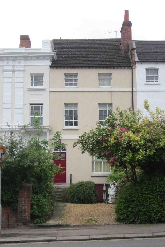
MATERIALS AND PLAN: the building is stuccoed with a red brick chimney stack. The roof covering is concrete tile. The house is of three storeys plus basement.
EXTERIOR: the entrance fronts onto Castle Hill. The ground floor contains a large, margin-glazed sash window on the western side of the elevation and a six-panelled door under a sunburst fanlight, accessed via a flight of stone steps with an iron handrail on the eastern side. There are two, six-over-six sash windows on the first floor and two, three-over-six sash windows on the second floor. There are plat bands at first- and second-floor sill height, and brick dentils beneath the steeply-pitched roof. The rear elevation is also rendered and contains sash windows on the ground, first and second floors. There is a shallow, two-storey extension along the eastern boundary of the property, adjoining 113 Castle Hill. It is stuccoed and has a hipped roof. The front area is a gravel drive with no boundary marker to the street.
Until the C19, most of the land west of Reading town centre was open farmland crossed by two ancient routes passing through the town from London to the West Country. Today, the northern of these two roads is named Oxford Road, while the southern is named Castle Street/Castle Hill/Bath Road. Fortifications were built throughout the area by Royalist forces garrisoned in the town during the Civil War with some of the earthworks surviving into the early C19. From the early C18, development slowly began to spread westward along Castle Hill/Bath Road and Oxford Road. More comprehensive development of the area began in the early C19 and progressed gradually over the next 100 years. Terraced housing was erected in considerable quantities during the first half of the C19 to cater for a variety of social groups.
115 Castle Hill is a terraced house that was constructed during the early C19, believed to be sometime after 1823, as part of the westward expansion of Reading’s inner suburbs. It appears to have been altered very little externally since construction, with the only addition being a two-storey rear extension abutting the neighbouring property at number 113, which was extant by 1875. An additional, larger rear extension also existed at this time but appears to have been removed by the early C20. The building has lost its original front boundary treatment, with a gravel driveway open to the street, and the historic roof covering has been replaced, sometime during the later C20 with concrete tiles.
115 Castle Street, Reading is listed at Grade II for the following principal reasons:
Architectural interest:
* as an early-C19 building which contributes to the character of an architecturally varied historic streetscape.
Group value:
* the building is in close proximity to a large number of listed buildings and forms part of a strong historic grouping.
External links are from the relevant listing authority and, where applicable, Wikidata. Wikidata IDs may be related buildings as well as this specific building. If you want to add or update a link, you will need to do so by editing the Wikidata entry.


Other nearby listed buildings