Latitude: 50.3492 / 50°20'56"N
Longitude: -3.889 / 3°53'20"W
OS Eastings: 265703
OS Northings: 51622
OS Grid: SX657516
Mapcode National: GBR Q9.7GRL
Mapcode Global: FRA 28R3.LS3
Plus Code: 9C2R84X6+MC
Entry Name: Denbury House
Listing Date: 26 January 1967
Grade: II
Source: Historic England
Source ID: 1108066
English Heritage Legacy ID: 99722
ID on this website: 101108066
Location: Modbury, South Hams, Devon, PL21
County: Devon
District: South Hams
Civil Parish: Modbury
Built-Up Area: Modbury
Traditional County: Devon
Lieutenancy Area (Ceremonial County): Devon
Church of England Parish: Modbury St George
Church of England Diocese: Exeter
Tagged with: House
MODBURY CHURCH STREET SX 6451-6551 (south side) 7/129 No 16 (Denbury House) 26.1.67
GV II
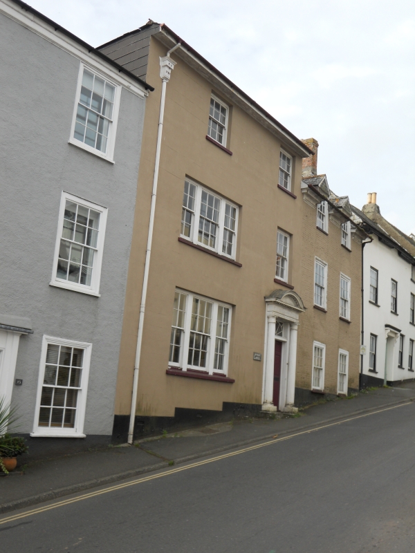
House in row, in two parts. Late C18 and mid C19. Left half is rendered, scribed as ashlar, right half in painted brickwork, both with slate roofs. To left, 3 storeys, 2 windows; at ground and first floors, left, tripartite 8:12:8-pane sashes, remainder small 12-pane sashes. To right 6-panel door to fanlight-in-square set to lofty fluted 'Egyptian' column doorcase to dentilled entablature and segmental pediment on single stone step; stepped plinth. Back has sashes in slate hanging, and a large brick stack part-way up roof slope. To right, 2 1/2 storeys, 2 windows; 12-pane sashes in moulded architraves and to segmental relieving arches to ground and first floors; at eaves are half-dormers containing 12-pane sashes. roof, which is independent of left half, is swept out at eaves over 3 sections of moulded cornice. Stepped plinth; ground floor windows set low to pavement level. There is a deep wing with large external stack.
Listing NGR: SX6570351622
External links are from the relevant listing authority and, where applicable, Wikidata. Wikidata IDs may be related buildings as well as this specific building. If you want to add or update a link, you will need to do so by editing the Wikidata entry.


Other nearby listed buildings