Latitude: 51.7589 / 51°45'31"N
Longitude: -0.2237 / 0°13'25"W
OS Eastings: 522691
OS Northings: 208179
OS Grid: TL226081
Mapcode National: GBR J9L.Q87
Mapcode Global: VHGPS.21LZ
Plus Code: 9C3XQQ5G+GG
Entry Name: Howe Dell School
Listing Date: 9 December 1983
Grade: II
Source: Historic England
Source ID: 1100998
English Heritage Legacy ID: 158454
ID on this website: 101100998
Location: Oxlease, Welwyn Hatfield, Hertfordshire, AL10
County: Hertfordshire
District: Welwyn Hatfield
Civil Parish: Hatfield
Built-Up Area: Hatfield
Traditional County: Hertfordshire
Lieutenancy Area (Ceremonial County): Hertfordshire
Church of England Parish: Bishops Hatfield Saint Etheldreda with Saint Luke
Church of England Diocese: St.Albans
Tagged with: Building
Hatfield New Town TL 20 NW HATFIELD OLD RECTORY DRIVE (west side)
8/191 Howe Dell School
-
- II
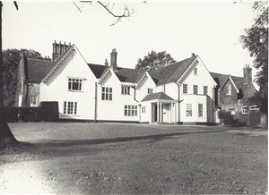
Former manor house and parsonage, now school. Probably C15 origin. Altered 1534, C17 and late C18 when stable block on E was built to form L plan. Original part is roughcast and plaster with plain tile roof. 2 storeys and attics. 5 gable ends with cusped bargeboards. Left hand gable to former cross wing is larger. Irregularly spaced and leaded casement windows. Projecting right hand C19 addition with canted ground floor sash window. Tall C19 chimney stacks with diagonal shafts. Rear elevation with 4-window early C19 centre. C17 red brick N wing. E wing is 2:2:2 windows. Red brick. 2 storeys with floor band and slightly projecting pedimented centre. Small segmental- headed glazing bar sashes. Brick dentil eaves. Plain tile hipped roof. (Hatfield W.E.A. pp. 9-11)
Listing NGR: TL2269108179
External links are from the relevant listing authority and, where applicable, Wikidata. Wikidata IDs may be related buildings as well as this specific building. If you want to add or update a link, you will need to do so by editing the Wikidata entry.


Other nearby listed buildings