Latitude: 52.2517 / 52°15'6"N
Longitude: -2.1849 / 2°11'5"W
OS Eastings: 387476
OS Northings: 261517
OS Grid: SO874615
Mapcode National: GBR 1FF.SHN
Mapcode Global: VH92G.2NTQ
Plus Code: 9C4V7R28+M3
Entry Name: Cooks Hill
Listing Date: 14 March 1969
Grade: II
Source: Historic England
Source ID: 1096358
English Heritage Legacy ID: 148128
ID on this website: 101096358
Location: Salwarpe, Wychavon, Worcestershire, WR9
County: Worcestershire
District: Wychavon
Civil Parish: Salwarpe
Traditional County: Worcestershire
Lieutenancy Area (Ceremonial County): Worcestershire
Church of England Parish: Salwarpe and Hindlip with Martin Hussingtree
Church of England Diocese: Worcester
Tagged with: Building
SO 86 SE SALWARPE CP SALWARPE
4/232 Cooks Cooks Hill
14.3.69 - II
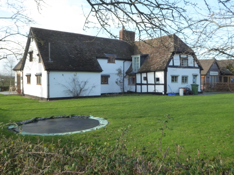
Also called The Tappet Hen. Shown on OS map as Cookshill Cottage. House. C15, altered and extended probably late C17 and mid-C20. Timber- framed, painted brick and rendered infill on sandstone rubble base, brick replacement walling, refacing and additions, plain tiled roofs, half-hipped to front wing, large brick central ridge stack with three square shafts and joint cap, also small ridge stack to west wing. Former cruck hall house of four bays with two-bay hall, one bay of which is now occupied by large chimney, on roughly north/south axis with gable end facing road and single bay additions at centre of both side elevations to form cruciform plan; east wing extended mid-C20; single storey and attic with dormers. Framing: visible mainly in right side elevation; two and three panels from sill to wall-plate, long straight braces in west wing gable end, end cruck trusses now replaced by collar-and-tie-beam trusses with queen struts. Front elevation facing road: north end bay of original part projects; gable end has two 2-light casements, one with plank weathering, one with cambered head, 2-light attic casement with plank weathering and, at right side, a narrow door with lean-to canopy on shaped brackets; in left side elevation is a C20 square light, 2-light casement and flat-roofed dormer with casement and in the right side elevation is a 3-light C20 casement and gabled dormer with 2-light casement; projecting from the main range to the left is a C17 single bay wing, brick with a 2- course band above ground floor level, a 3-light ground floor casement and a half-dormer with catslide roof and 2-light casement; to the left of this is the C20 addition; projecting to the right of the main range is the other C17 single bay wing in which there is a 2-light casement. To the rear of this wing is the present main entrance of C20 date. Interior: three cruck trusses are retained; back-to-back inglenook fireplaces in lower bay of hall and inserted floor.
Listing NGR: SO8747661517
External links are from the relevant listing authority and, where applicable, Wikidata. Wikidata IDs may be related buildings as well as this specific building. If you want to add or update a link, you will need to do so by editing the Wikidata entry.


Other nearby listed buildings