Latitude: 51.9707 / 51°58'14"N
Longitude: -1.8748 / 1°52'29"W
OS Eastings: 408700
OS Northings: 230260
OS Grid: SP087302
Mapcode National: GBR 3MZ.DVF
Mapcode Global: VHB1F.GQ7L
Plus Code: 9C3WX4CG+73
Entry Name: Sheep Dip
Listing Date: 11 January 1985
Grade: II
Source: Historic England
Source ID: 1089525
English Heritage Legacy ID: 128711
ID on this website: 101089525
Location: Cutsdean, Cotswold, Gloucestershire, GL54
County: Gloucestershire
District: Cotswold
Civil Parish: Cutsdean
Traditional County: Gloucestershire
Lieutenancy Area (Ceremonial County): Gloucestershire
Church of England Parish: Temple Guiting St Mary
Church of England Diocese: Gloucester
Tagged with: Building
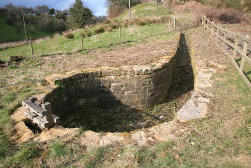
CUTSDEAN CUTSDEAN VILLAGE SP 03 SE 2/73 Sheep dip II Sheep dip. C19. Coursed squared and dressed limestone dip, with limestone rubble retaining walls to either side of exit ramp. 'b' shaped plan comprising circular dip about 2m in depth and about 4m wide with wooden sluice gate on lower side and cobbled exit ramp opposite.
Listing NGR: SP0870030260
External links are from the relevant listing authority and, where applicable, Wikidata. Wikidata IDs may be related buildings as well as this specific building. If you want to add or update a link, you will need to do so by editing the Wikidata entry.


Other nearby listed buildings