Latitude: 51.3296 / 51°19'46"N
Longitude: 1.4156 / 1°24'56"E
OS Eastings: 638044
OS Northings: 164487
OS Grid: TR380644
Mapcode National: GBR X0L.JR0
Mapcode Global: VHMCW.HV82
Plus Code: 9F338CH8+R7
Entry Name: No 1 and Railed Area
Listing Date: 13 September 1974
Grade: II
Source: Historic England
Source ID: 1085316
English Heritage Legacy ID: 171914
ID on this website: 101085316
Location: Ramsgate, Thanet, Kent, CT11
County: Kent
District: Thanet
Civil Parish: Ramsgate
Built-Up Area: Ramsgate
Traditional County: Kent
Lieutenancy Area (Ceremonial County): Kent
Tagged with: Building
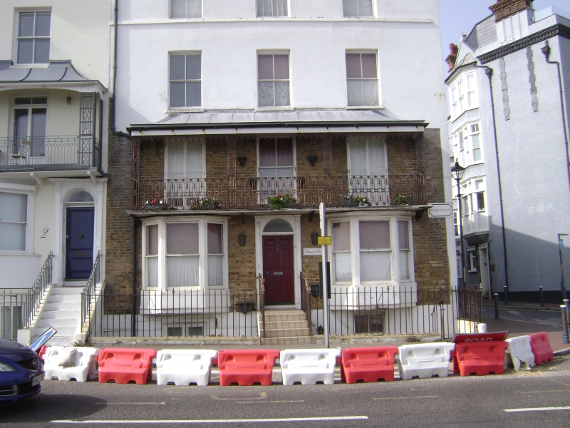
RAMSGATE THE PARAGON TR 3864 SW 19/281 No. 1 and railed area 13.9.74 GV II House. Circa 1816. White stock brick, in part rendered, with plain tiled roof. Four storeys, basement and attic, with string-course and parapet to hipped roof with flat-roofed dormer. Regular fenestration of 3 sashes on 2nd floor and 3rd floors, and 2 French windows on 1st floor, with central sash. Tented verandah with wrought valancing and with pierced iron piers and wrought baluster rail. Two canted oriels on ground floor, and metal casement to basement, partly roofed over. Central door of 6 raised and fielded panels with semi-circular fanlight in panelled and moulded surround, at head of flight of steps. Simple iron rails. Although a fine Regency building, not apparently of the same build orcharacter as the main terrace (see No. 4, item 19/284 ).
Listing NGR: TR3804464487
External links are from the relevant listing authority and, where applicable, Wikidata. Wikidata IDs may be related buildings as well as this specific building. If you want to add or update a link, you will need to do so by editing the Wikidata entry.


Other nearby listed buildings