Latitude: 51.0508 / 51°3'2"N
Longitude: 0.5906 / 0°35'25"E
OS Eastings: 581667
OS Northings: 131135
OS Grid: TQ816311
Mapcode National: GBR QWC.04N
Mapcode Global: FRA D63B.RW3
Plus Code: 9F323H2R+86
Entry Name: Dingleden House
Listing Date: 9 June 1952
Grade: II
Source: Historic England
Source ID: 1085215
English Heritage Legacy ID: 170193
ID on this website: 101085215
Location: Dingleden, Tunbridge Wells, Kent, TN17
County: Kent
District: Tunbridge Wells
Civil Parish: Benenden
Traditional County: Kent
Lieutenancy Area (Ceremonial County): Kent
Tagged with: House
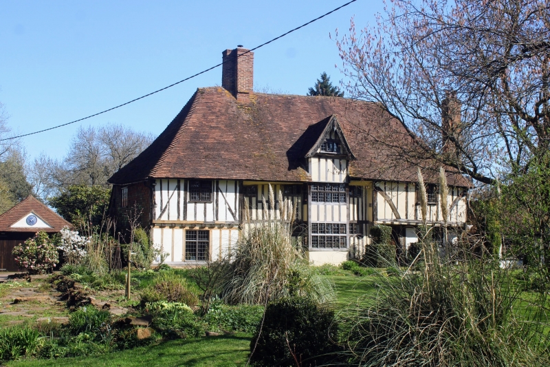
BENENDEN TQ83SW RAMSDEN LANE (OFF) 1350-0/8/86 Dingleden House 09/06/52 II House, formerly farmhouse. C15 timberframed open hall-house altered in C16 and restored in C20. Front has exposed close-studding with plaster infill, the left side elevation is tile hung. Rear elevation has C20 brick extension. Steeply pitched C20 tiled roof with cruciform brick chimneystack. 2 storeys. 4 windows. Mainly mullioned windows with diamond-shaped leaded panes. The 1st floor of the end window bays originally oversailed on the protruding ends of the floor joists and brackets with curved braces, but the north bay has been underbuilt and the ground floor below the south overhang has been refaced in red brick. The centre portion has coved eaves and a bay on both floors containing 2 tiers of 7 lights with wooden mullions and transoms, each flanked by a tiny window, with a gable above oversailing on a curved bressumer and containing an attic window and pendant. Restored door flanked by durns.
Listing NGR: TQ8166731135
External links are from the relevant listing authority and, where applicable, Wikidata. Wikidata IDs may be related buildings as well as this specific building. If you want to add or update a link, you will need to do so by editing the Wikidata entry.


Other nearby listed buildings