Latitude: 51.1243 / 51°7'27"N
Longitude: 0.4125 / 0°24'44"E
OS Eastings: 568919
OS Northings: 138883
OS Grid: TQ689388
Mapcode National: GBR NRH.H3L
Mapcode Global: VHJMY.3ZDZ
Plus Code: 9F324CF6+PX
Entry Name: Pullens Farmhouse
Listing Date: 10 October 1989
Grade: II
Source: Historic England
Source ID: 1084529
English Heritage Legacy ID: 169889
ID on this website: 101084529
Location: Hazel Street, Tunbridge Wells, Kent, TN12
County: Kent
District: Tunbridge Wells
Civil Parish: Horsmonden
Traditional County: Kent
Lieutenancy Area (Ceremonial County): Kent
Church of England Parish: Horsmonden St Margaret
Church of England Diocese: Rochester
Tagged with: Farmhouse
HORSMONDEN LAMBERHURST ROAD TQ 63 NE (east side) 3/53 Pullens Farmhouse II
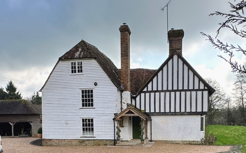
House. Circa 1500, extended C16/C17 and altered C19. Timber framed and part exposed with plaster infill, part rendered and extended with weather boarded frame. Plain tiled roofs. Wealden hall house in origin. The hall house range to south, of 2 storeys on plinth with jetty to left and recessed hall bay to right, the eaves carried on arched braces. The right end bay has been destroyed, a single post now supports the eaves brace. Roof half-hipped to right, gabled to left with stack. Three light and two 2 light wooden casements on first floor and canted bay, 5 light mullioned and leaded window and glazed door on ground floor. The end left bay with its jetty returned to left is a C19 extension. Right return with framing in St.Andrews cross pattern. Wing added to rear C16/C17, of 2 storeys and garret with half-hipped roof and stacks to right and to left, the latter with massive sandstone base, offset and tumbled-in English bond brickwork and truncated flue. Glazing bar sashes on each floor. Panelled door in lean to outshot to right of rear wing, and single storey extension with stack to rear left. Interior: open truss roof, the framing evidence suggests the lost east end of the Vealden was the service end; knee braced and chamfered principal tie beam and hood moulded door and window surrounds and moulded main beams. See E.Mercer, English Vernacular Houses, p.175.
Listing NGR: TQ6891938883
External links are from the relevant listing authority and, where applicable, Wikidata. Wikidata IDs may be related buildings as well as this specific building. If you want to add or update a link, you will need to do so by editing the Wikidata entry.


Other nearby listed buildings