Latitude: 52.2594 / 52°15'33"N
Longitude: -2.7513 / 2°45'4"W
OS Eastings: 348815
OS Northings: 262620
OS Grid: SO488626
Mapcode National: GBR BJ.ZWW5
Mapcode Global: VH84P.8GBT
Plus Code: 9C4V765X+PF
Entry Name: Lustonbury
Listing Date: 11 June 1959
Last Amended: 11 December 1987
Grade: II
Source: Historic England
Source ID: 1081842
English Heritage Legacy ID: 150090
ID on this website: 101081842
Location: Luston, County of Herefordshire, HR6
County: County of Herefordshire
Civil Parish: Luston
Built-Up Area: Luston
Traditional County: Herefordshire
Lieutenancy Area (Ceremonial County): Herefordshire
Church of England Parish: Eye
Church of England Diocese: Hereford
Tagged with: Building
SO 4863 LUSTON CP MAIN STREET (east side)
12/68 Lustonbury (formerly listed as Bury 11.6.59 Farmhouse)
GV II
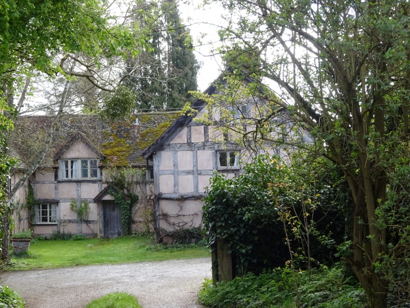
Farmhouse. Possibly C15, remodelled late C17 with some early C19 altera- tions, restored 1980's. Timber with rendered and painted brick infill on a rubble plinth, partially rendered with tile roof. U-plan, the main range aligned north/south possibly C15, the south cross-wing extending to the west of C17. At the north end a single-bay wing projects to the east. Against north end of main range there is a C19 lean-to which incorporates one wall of an earlier cross-wing. Two main stacks, one in centre of south wing, the other towards the north end of the main range, both with linked diamond-plan brick shafts. West front rendered. Central main range of one storey with attic, lit by a gabled dormer, on the ground floor a 3-light casement to left, entrance to right with gabled tiled canopy and C17 ledged and boarded door. Left-hand projecting wing of two storeys with a 3-light casement to each floor. Right-hand wing of two storeys with attic lit by a 3-light casement, a 2-light casement to first floor and a 3-light casement below. Bargeboards to gable are dentilled, and there is a finial. The east gable of this wing is similarly detailed with a blocked window which has original moulded mullions. Framing: hall range of three square panels high, south cross-wing four rectangular panels with a gable-end truss which has two collars and multiple struts, with V-struts in the apex and trenched purlins. Interior of main range has hints of a smoke-blacked roof, indicating an open hall. Close-studded wall of former cross-wing survives inside C19 lean-to at north end. Main stack in this range has an inglenook on each side the northern mantel beam truncated in C19 for the bread oven. Stack in south wing has four fireplaces, each with a simply moulded stone surround of C17. The adjoining staircase has an octagonal central newel and solid treads. The adjoining barn (qv) and cart shed (qv) are known as Bury Farm. (RCHM, 3, p 140, no 23).
Listing NGR: SO4881562620
External links are from the relevant listing authority and, where applicable, Wikidata. Wikidata IDs may be related buildings as well as this specific building. If you want to add or update a link, you will need to do so by editing the Wikidata entry.


Other nearby listed buildings