Latitude: 52.6209 / 52°37'15"N
Longitude: -0.624 / 0°37'26"W
OS Eastings: 493249
OS Northings: 303464
OS Grid: SK932034
Mapcode National: GBR DTM.R1L
Mapcode Global: WHGM1.DD32
Plus Code: 9C4XJ9CG+9C
Entry Name: Manor Farmhouse
Listing Date: 10 November 1955
Last Amended: 29 June 1984
Grade: II*
Source: Historic England
Source ID: 1073863
English Heritage Legacy ID: 187047
ID on this website: 101073863
Location: North Luffenham, Rutland, LE15
County: Rutland
Civil Parish: North Luffenham
Built-Up Area: North Luffenham
Traditional County: Rutland
Lieutenancy Area (Ceremonial County): Rutland
Church of England Parish: North Luffenham St John the Baptist
Church of England Diocese: Peterborough
Tagged with: Farmhouse
NORTH LUFFENHAM SK 90 SW LYNDON ROAD (North Side)
6/207 Manor Farmhouse (formerly listed under Clay Lane) 10.11.55
GV II*
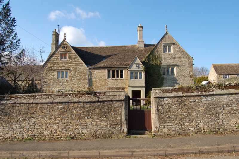
House. Dated 1640. Coursed rubble stone and ashlar with quoins and stone dressings and Collyweston slate roof with moulded stone ridge and end stacks. Stone coped shouldered gables,some with finials. Gabled wings either end, ashlar 2 storey porch centre right. 2½ storeys of 4 mostly stone mullion windows. On left wing gable a 3-light casement with cambered lintel and 3-light stone mullion with hood mould. Blocked 2-light over. In central section a 4-light stone mullion to both floors, the lower with hood mould, and to right the porch with a flat arched doorway, and 6-panelled door inside, 3-light stone mullion over, and sundial in gable. On right wing gable a 3-light stone mullion with stone jambs, stone tablet inscribed 1640 over, a 3-light stone mullion with hood mould to 1st floor, and similar blocked 2-light in gable. On left end 2 stone framed 1-lights and to rear a further span with brick left end stack. Stone fireplaces inside. Extending from left end a C19 barn with Welsh slate roof, hipped on left end. Central doorway with cambered brick lintel and double doors. 2 tiers of loop holes.
Listing NGR: SK9324903464
External links are from the relevant listing authority and, where applicable, Wikidata. Wikidata IDs may be related buildings as well as this specific building. If you want to add or update a link, you will need to do so by editing the Wikidata entry.


Other nearby listed buildings