Latitude: 53.7522 / 53°45'7"N
Longitude: -2.3681 / 2°22'4"W
OS Eastings: 375827
OS Northings: 428486
OS Grid: SD758284
Mapcode National: GBR CTX1.3P
Mapcode Global: WH96X.LYKD
Plus Code: 9C5VQJ2J+VQ
Entry Name: 21, Cannon Street
Listing Date: 9 March 1984
Grade: II
Source: Historic England
Source ID: 1072751
English Heritage Legacy ID: 183809
ID on this website: 101072751
Location: Accrington, Hyndburn, Lancashire, BB5
County: Lancashire
District: Hyndburn
Electoral Ward/Division: Barnfield
Parish: Non Civil Parish
Built-Up Area: Accrington
Traditional County: Lancashire
Lieutenancy Area (Ceremonial County): Lancashire
Church of England Parish: Accrington St James
Church of England Diocese: Blackburn
Tagged with: Building
ACCRINGTON CANNON STREET SD 72 NE No.21 7/13 - GV II
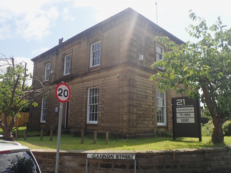
Town house, c.1860. Ashlar facade and side walls, rubble rear wall, hipped slate roof with chimney at left side. Double pile 3 bay plan. Two storeys in classical style; rusticated quoins, channelled rustication to ground floor, string course, moulded eaves cornice on consoles. Symmetrical; central panelled door with fanlight in recessed architrave, rusticated surround with keystone above which a small cornice on consoles breaks forward from the string course. Two ground floor windows with rusticated surrounds, and three 1st floor windows with eared architraves, are all sashed with glazing bars; right return wall has similar windows. Rear wall has service wing to 1st bay and a round headed stairlight with glazing bars.
Listing NGR: SD7582728486
External links are from the relevant listing authority and, where applicable, Wikidata. Wikidata IDs may be related buildings as well as this specific building. If you want to add or update a link, you will need to do so by editing the Wikidata entry.


Other nearby listed buildings