Latitude: 51.6513 / 51°39'4"N
Longitude: -1.2761 / 1°16'33"W
OS Eastings: 450180
OS Northings: 194972
OS Grid: SU501949
Mapcode National: GBR 7YY.G5P
Mapcode Global: VHCY6.TRRG
Plus Code: 9C3WMP2F+GH
Entry Name: Church of St Paul
Listing Date: 18 July 1963
Grade: II
Source: Historic England
Source ID: 1059792
English Heritage Legacy ID: 248822
Also known as: St Paul's Church, Culham
ID on this website: 101059792
Location: St Paul's Church, Culham, South Oxfordshire, OX14
County: Oxfordshire
District: South Oxfordshire
Civil Parish: Culham
Built-Up Area: Culham
Traditional County: Oxfordshire
Lieutenancy Area (Ceremonial County): Oxfordshire
Church of England Parish: Culham
Church of England Diocese: Oxford
Tagged with: Church building
CULHAM THE GREEN SU5094 (South side) 12/37 Church of St. Paul 18/07/63
GV II
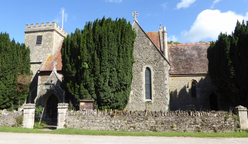
Church. Tower c.1710; nave, aisles and south transept c.1852 by Joseph Clarke; chancel c.1872 by R.P. Spiers. Uncoursed stone rubble to tower; squared coursed stone to church with ashlar stone dressings; old plain-tile roof; roof of tower not visible. 4-bay nave and north aisle, south transept, chancel and west tower. Early English style. 2-centred archway with hood mould and triangular moulded surround to porch to left of centre of nave. Double plank doors with wrought iron hinges to 2-centre arched doorway. 2-light plate tracery and trefoil lancet windows. Doorway with plank door to base of tower; tower of 2 stages. Louvred opening to each side of top of tower. Plain parapet to tower with stepped corners. Interior: wooden barrel-vault to chancel, 4-bay arch-braced collar truss roof to nave. C19 stencil decoration to chancel walls. Piscina to right of chancel. 2-centred chancel arch on half-columns. 2-centred transept arch on corbels. Aisle arcade of three 2-centred arches on columns. C19 pews with wrought iron candelabra to ends. C19 octagonal stone font with pierced wood cover. (Buildings of England: Oxfordshire, 1974, p.565; V.C.H.: Oxfordshire, Vol.7, 1962, p.37).
Listing NGR: SU5018094972
External links are from the relevant listing authority and, where applicable, Wikidata. Wikidata IDs may be related buildings as well as this specific building. If you want to add or update a link, you will need to do so by editing the Wikidata entry.


Other nearby listed buildings