Latitude: 52.3607 / 52°21'38"N
Longitude: -2.9541 / 2°57'14"W
OS Eastings: 335120
OS Northings: 274053
OS Grid: SO351740
Mapcode National: GBR B8.SFC0
Mapcode Global: VH76J.RX3P
Plus Code: 9C4V926W+78
Entry Name: Turkey Hall
Listing Date: 28 May 1987
Grade: II
Source: Historic England
Source ID: 1054993
English Heritage Legacy ID: 257536
ID on this website: 101054993
Location: Bucknell, Shropshire, SY7
County: Shropshire
Civil Parish: Bucknell
Built-Up Area: Bucknell
Traditional County: Shropshire
Lieutenancy Area (Ceremonial County): Shropshire
Church of England Parish: Bucknell
Church of England Diocese: Hereford
Tagged with: Building
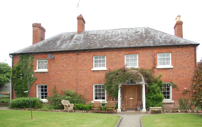
BUCKNELL C.P. CHAPEL LAWN ROAD (north SO 37 SE side), Bucknell 12/32 Turkey Hall - II - Farmhouse, now house. Circa 1800, extended to left shortly afterwards with minor later alterations. Uncoursed limestone rubble with red brick facade; hipped slate roof with red brick ridge stack to left of centre and integral brick end stacks. Original 3-bay house apparently extended to left in early C19, although no straight joint is visible to front. 2 storeys with dentilled eaves cornice. 4-window front, left window to far left, glazing bar sashes with gauged heads. Originally central round-arched entrance has 6-panel door and wreathed and radiating fanlight, similar to that at Weir House (q.v.).
Listing NGR: SO3512074053
External links are from the relevant listing authority and, where applicable, Wikidata. Wikidata IDs may be related buildings as well as this specific building. If you want to add or update a link, you will need to do so by editing the Wikidata entry.


Other nearby listed buildings