Latitude: 54.9221 / 54°55'19"N
Longitude: -1.903 / 1°54'10"W
OS Eastings: 406314
OS Northings: 558606
OS Grid: NZ063586
Mapcode National: GBR HC4J.SC
Mapcode Global: WHB2N.RJ0Z
Plus Code: 9C6WW3CW+RQ
Entry Name: Apperley Farmhouse
Listing Date: 15 April 1969
Last Amended: 18 June 1986
Grade: II
Source: Historic England
Source ID: 1045360
English Heritage Legacy ID: 240449
ID on this website: 101045360
Location: New Ridley, Northumberland, NE43
County: Northumberland
Civil Parish: Broomley and Stocksfield
Traditional County: Northumberland
Lieutenancy Area (Ceremonial County): Northumberland
Church of England Parish: Bywell St Peter
Church of England Diocese: Newcastle
Tagged with: Farmhouse
BROOMLEY AND STOCKSFIELD APPERLEY NZ 05 NE NZ 063586 11/78 Apperley Farmhouse (formerly listed as 15.4.69 Apperley) )
GV II
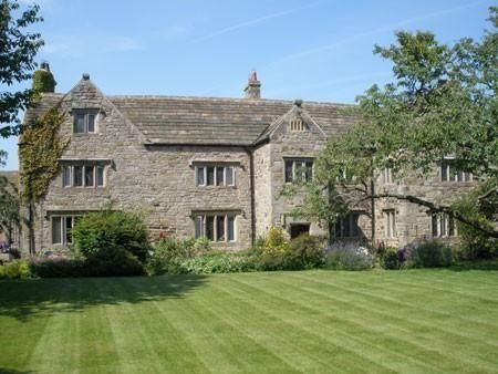
House, C17; major extension and remodelling c.1930 by Lord Gort, re-using old material and architectural features from Newcastle and elsewhere. Coursed large rubble with roughly-shaped quoins, cut dressings; stone slate roof except for Welsh slates to rear.
South elevation 2 storeys + attics, 5 bays, the 2 left bays being the original house. Gabled end and central bays, the latter a projecting porch; right bay also projects. Renewed door in moulded surround with flat-pointed head and hoodmould. 3-light 1st floor window; stone with 4 pierced lancets and carving in gable. Multiple-light stone-mullioned windows, with latticed glazing, under hoodmoulds. Gable finials. Left end stack with diagonally-set shafts; large projecting stack on right return. Rear elevation shows 2-bay north front of original house to right, partly concealed by later additions; flat-faced mullioned windows. Interior; many C17 features, door surrounds, fireplaces, beamed ceilings and fine early C17 open-well stair, all imported except for two fireplaces with moulded surrounds. Stone stair down to well beneath kitchen of old house. The home of the Boutflower family from the early C17 until 1766; in 1675 Thomas Boutflower was taxed on 8 chimneys.
Listing NGR: NZ0631458606
External links are from the relevant listing authority and, where applicable, Wikidata. Wikidata IDs may be related buildings as well as this specific building. If you want to add or update a link, you will need to do so by editing the Wikidata entry.


Other nearby listed buildings