Latitude: 54.9604 / 54°57'37"N
Longitude: -2.469 / 2°28'8"W
OS Eastings: 370068
OS Northings: 562959
OS Grid: NY700629
Mapcode National: GBR CC62.8N
Mapcode Global: WH912.1LL5
Plus Code: 9C6VXG6J+4C
Entry Name: Bellister Castle
Listing Date: 10 June 1952
Grade: I
Source: Historic England
Source ID: 1045292
English Heritage Legacy ID: 240693
ID on this website: 101045292
Location: Northumberland, NE49
County: Northumberland
Civil Parish: Featherstone
Traditional County: Northumberland
Lieutenancy Area (Ceremonial County): Northumberland
Church of England Parish: Haltwhistle Holy Cross
Church of England Diocese: Newcastle
Tagged with: Castle Manor house
FEATHERSTONE BELLISTER ROAD NY 76 SW (South side, off) 16/89 Bellister Castle 10/6/52 (formerly listed in the Civil Parish of Bellister)
GV I
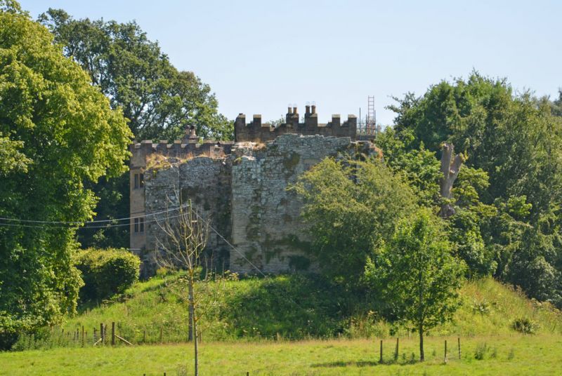
Ruined tower house and adjoining occupied house. Ruined section possibly a C13 hall-house with C14 (possibly solar) tower on west; altered c.1600. Occupied house dated 1669 but possibly incorporating medieval fabric in lower courses; major alterations c.1826 by John Dobson and c.1890; partly rebuilt c.1901-5 following an extensive fire. Tower coursed rubble with dressings; roofless. House squared and snecked sandstone, roofs not visible. L-plan medieval range with U-plan occupied house on east end. Castellated style house.
Ruined section of 2 builds retains few architectural details. Original north and west walls are 2 and 3 storeys high, south wall has partly collapsed and east wall is largely destroyed. Projecting north-west corner with alternating quoins; fragment of spiral stair near south-west corner. Narrower added tower on west has similar projecting corners; fragmentary window openings on north; window in surround with double-roll moulding set high on west; fragment of garderobe on partly-collapsed south wall.
Occupied house has mainly C19 2- and 3-light mullioned windows and embattled parapets. North front has recessed centre and projecting wings: 3-storey, 3-bay centre has possibly re-set moulded ogee-headed doorway and 1669 datestone; slightly-projecting c.1890 tower on west, adjoining ruined section, with projecting single-storey wing on front; far-projecting early C19 2-storey east wing with flanking corner turrets, cross windows and a later 3-storey semi- octagonal tower on north-west corner. 2-storey, 3-bay east return has projecting tower with pointed doorway, flanking elaborate oriel windows and projecting corners. South front of 2 builds: recessed 3-storey, 3-bay centre; c.1890 tower at west with taller turret; wider 2-storey tower at east with projecting corners and turrets. Interior refitted in early C20.
Listing NGR: NY7006862959
External links are from the relevant listing authority and, where applicable, Wikidata. Wikidata IDs may be related buildings as well as this specific building. If you want to add or update a link, you will need to do so by editing the Wikidata entry.


Other nearby listed buildings