Latitude: 51.3459 / 51°20'45"N
Longitude: -2.2518 / 2°15'6"W
OS Eastings: 382557
OS Northings: 160782
OS Grid: ST825607
Mapcode National: GBR 1SC.FJB
Mapcode Global: VH96V.XFFM
Plus Code: 9C3V8PWX+87
Entry Name: 12 and 12A, St Margaret's Street
Listing Date: 23 August 1974
Grade: II
Source: Historic England
Source ID: 1036106
English Heritage Legacy ID: 312681
ID on this website: 101036106
Location: Bradford-on-Avon, Wiltshire, BA15
County: Wiltshire
Civil Parish: Bradford-on-Avon
Built-Up Area: Bradford on Avon
Traditional County: Wiltshire
Lieutenancy Area (Ceremonial County): Wiltshire
Church of England Parish: Bradford-on-Avon Holy Trinity
Church of England Diocese: Salisbury
Tagged with: Building
1. ST MARGARET'S STREET 5411 (East Side)
Nos 12 and 12A ST 8260 2/267
II GV
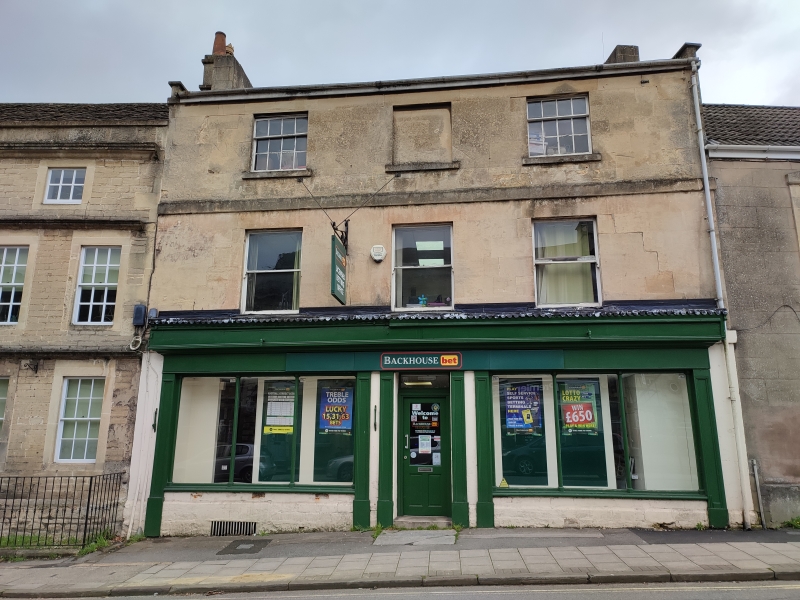
2. Early C19. 3 storeys. Ashlar. Slate roof with eaves and end gable parapets with kneelers. Stringcourse between first and second floor. 3 windows. Sashes with glazing bars to second floor (centre window blocked), later sashes to first floor. Late C19 double shop-front and entrance under overall fascia, with moulded entablature and moulded pilasters. Thin colonnettes with foliated capitals dividing the glazing.
The Three Horseshoes and Nos 1 to 4 (consec) Frome Road form a group with the Liberal Club, The Baptist Chapel, the Congregational Church and Hall and Nos 6 to 16 (consec), 19 to 22 (consec), 36, 42 to 49 (consec) and Westbury House, St Margaret's Street and No 1 St Margaret's Hill.
Listing NGR: ST8255960783
External links are from the relevant listing authority and, where applicable, Wikidata. Wikidata IDs may be related buildings as well as this specific building. If you want to add or update a link, you will need to do so by editing the Wikidata entry.


Other nearby listed buildings