Latitude: 52.4968 / 52°29'48"N
Longitude: -1.7054 / 1°42'19"W
OS Eastings: 420099
OS Northings: 288807
OS Grid: SP200888
Mapcode National: GBR 4H4.FP5
Mapcode Global: VHBWG.DH9T
Plus Code: 9C4WF7WV+PV
Entry Name: 148, High Street
Listing Date: 11 November 1952
Grade: II
Source: Historic England
Source ID: 1034671
English Heritage Legacy ID: 309364
ID on this website: 101034671
Location: Coleshill, North Warwickshire, B46
County: Warwickshire
District: North Warwickshire
Civil Parish: Coleshill
Built-Up Area: Coleshill
Traditional County: Warwickshire
Lieutenancy Area (Ceremonial County): Warwickshire
Church of England Parish: Coleshill
Church of England Diocese: Birmingham
Tagged with: Building
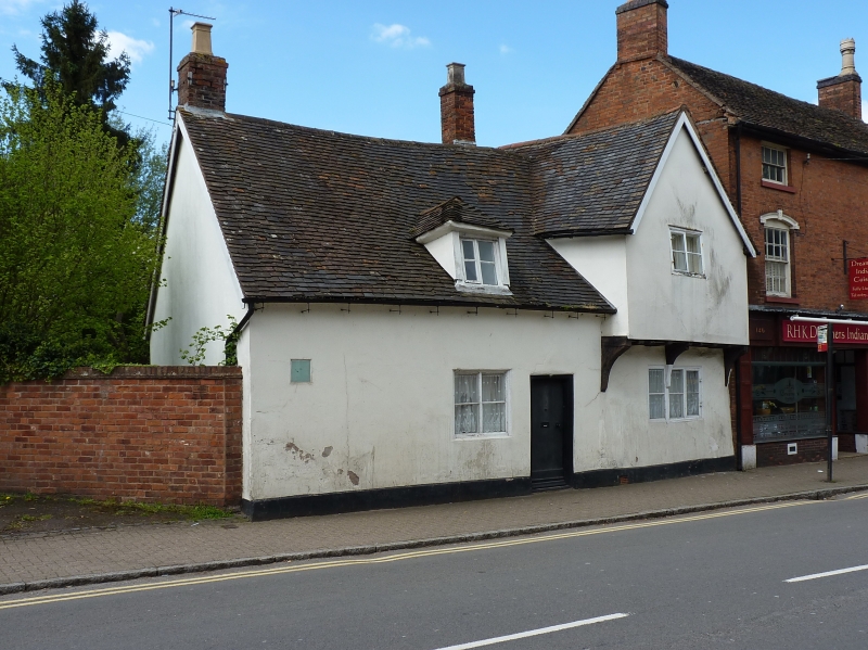
COLESHILL HIGH STREET SP2088-2188 (West side) 11/50 No.148 11/11/52 GV II House. C15. Roughcast timber framing; plain tile roof; brick ridge stack and integral end stack. Single-ended hall-house with single-bay hall and northern cross-wing forming a T-shaped plan. One storey and attic. Hall range to the left with 4-pane fixed light ground floor window and a central attic dormer casement with hipped roof. Plank door to the right. The gabled cross-wing to the right has a jettied attic storey on 3 curved brackets, a 3-light casement to the ground storey and a 2-light casement to the attic. Interior not inspected but the VCH records wide flat ceiling joists and curved windbraces in the cross-wing, an inserted C16 ceiling with stop-chamfered beam in the hall range together with a wide fireplace in the south wall, and a triangular-headed door way between hall and cross-wing. (VCH: Warwickshire: Vol IV: 1965: p48)
Listing NGR: SP2009988807
External links are from the relevant listing authority and, where applicable, Wikidata. Wikidata IDs may be related buildings as well as this specific building. If you want to add or update a link, you will need to do so by editing the Wikidata entry.


Other nearby listed buildings