Latitude: 51.3594 / 51°21'33"N
Longitude: -1.8669 / 1°52'0"W
OS Eastings: 409365
OS Northings: 162267
OS Grid: SU093622
Mapcode National: GBR 3WB.NTZ
Mapcode Global: VHB4J.L3F6
Plus Code: 9C3W945M+Q7
Entry Name: Manor Farmhouse
Listing Date: 19 March 1962
Grade: II
Source: Historic England
Source ID: 1033725
English Heritage Legacy ID: 311613
ID on this website: 101033725
Location: Stanton St Bernard, Wiltshire, SN8
County: Wiltshire
Civil Parish: Stanton St. Bernard
Traditional County: Wiltshire
Lieutenancy Area (Ceremonial County): Wiltshire
Tagged with: Farmhouse
STANTON ST BERNARD THE STREET SU 06 SE (east side) 7/193 Manor Farmhouse 19.3.62 II
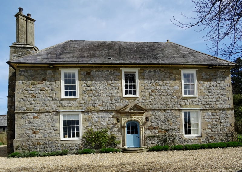
Manor house, later farm, now house. C17 and early C19. Sarsen with limestone dressings. Slate roof. 'L'-plan, front block of 3 bays with central stair hall, and service wing to rear beyond through passage behind left parlour. Re-entrant angle brought out to square in early C19 and reroofed with parallel ridge. Elevation 2 storeys, 3 bays, with limestone quoins, water sill, string and drip moulding over windows. Central entrance with half-glazed door under anse-de-panier arch, surrounded by bolection mouldings with capitals and draped shields in arch spandrels, and large dropped keystone. Pulvinated frieze over and broken pediment enclosing a small urn. Datestone reading S / M. E / 1677 with volutes over, probably Michael Smith and wife. Blind oval keyed oculi at either side of door. Windows early C19, sixteen-pane sashes to ground floor, 12-pane to upper floor, replacing rebated ovolo cross windows, which remain on both floors of right gable return. Modillion eaves and roof hipped. Rear wing on left; added early C19, is of brick, 2 bays, 2 storeys; and a further extension beyond a through passage, single storey containing service rooms. Internally, early C19 stair and doors. Two C17 eared architraves to doors at first floor level. Windows have scratched graffiti with names of William (Smith) and Barbara Hay, dated 1720.
Listing NGR: SU0936562267
External links are from the relevant listing authority and, where applicable, Wikidata. Wikidata IDs may be related buildings as well as this specific building. If you want to add or update a link, you will need to do so by editing the Wikidata entry.


Other nearby listed buildings