Latitude: 52.2219 / 52°13'18"N
Longitude: 1.3456 / 1°20'44"E
OS Eastings: 628612
OS Northings: 263461
OS Grid: TM286634
Mapcode National: GBR WNN.R0J
Mapcode Global: VHLB4.8FQ1
Plus Code: 9F4368CW+Q6
Entry Name: 9, Double Street
Listing Date: 25 October 1951
Last Amended: 18 December 1985
Grade: II
Source: Historic England
Source ID: 1030360
English Heritage Legacy ID: 286344
ID on this website: 101030360
Location: Framlingham, East Suffolk, IP13
County: Suffolk
District: East Suffolk
Civil Parish: Framlingham
Built-Up Area: Framlingham
Traditional County: Suffolk
Lieutenancy Area (Ceremonial County): Suffolk
Church of England Parish: Framlingham St Michael
Church of England Diocese: St.Edmundsbury and Ipswich
Tagged with: Building
TM 26 SE FRAMLINGHAM DOUBLE STREET (NORTH WEST SIDE)
4/66 No.9 (formerly listed as 25.10.51 No.7, No.9)
GV II
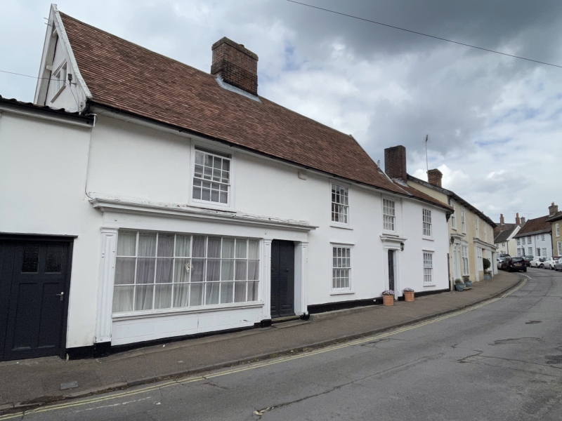
House, formerly divided into 2. Late C16 and early C17, with later front. 2 storeys. Timber-framed and rendered; plaintiled roofs; overhanging eaves. The right-hand end of the building is an addition which has had the front slope of its roof raised: it has a shallower pitch and lower ridge than the remainder of the roof. An internal chimney-stack with a plain red brick shaft. 4 small-paned sash windows in flush frames to the upper floor, and 2 similar windows to the ground floor. A former early C19 small-paned shop window and door beneath a single entablature supported by 3 panelled pilasters. Slightly recessed 4-panelled entrance door with moulded entablature and panelled pilasters. The oldest part of the house has a much- altered lobby-entrance form, with good, plain framing inside; long arched braces at the corners; several blocked original windows. The 2 bays at the right end have the roof-timbers exposed on the upper storey: one row of butt purlins and one of clasped purlins; straight windbraces; narrow diminished principals. A small C19 extension at the left side has double doors and is used as a garage with a room above.
Listing NGR: TM2861263461
External links are from the relevant listing authority and, where applicable, Wikidata. Wikidata IDs may be related buildings as well as this specific building. If you want to add or update a link, you will need to do so by editing the Wikidata entry.


Other nearby listed buildings